


ais class b
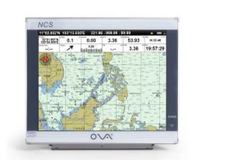
Product Description The AIS electronics chartplotter with 17 inch is built-in the GPS positioning function. Product Specification Packing&Shipping Our Service Technical Support Our company has three senior technicians and twelve professionals with high technological level, abundant...
Product Introduction
Marine ais class b Chartplotter ensures that you are seen by other AIS equipped vessels.
Product Description of the ais class b chart plotter
The ais class b chartplotter with 17 inch is built-in the GPS positioning function.
The AIS Class B Chartplotter with a 17-inch display is a state-of-the-art marine navigation system designed to elevate safety, precision, and efficiency on the water. Combining robust AIS (Automatic Identification System) Class B technology with built-in GPS positioning, this chartplotter is engineered to meet the demands of commercial vessels, recreational boaters, and maritime professionals. Its expansive 17-inch high-resolution screen, intuitive interface, and advanced features make it an indispensable tool for navigating coastal waters, busy harbors, and open seas.
Product Function of the ais class b chart plotter
●Bridge alarm function confirmed by maritime
●Text-to-speech technology; voice prompts and support.
●HDT input; capability for stable direction.
●Automatic tracking for AIS targets; real-time computing for distance and bearing to this vessel.
●Dynamic real-time rendering of all AIS targets for location and motion vectors.
●Dynamic information readouts for AIS targets; can send and receive AIS messages.
●Unlimited backlight adjustment; comfortable night usage patterns.
●Designed for embedded or countertop installation. Countertop installation supports multi-angle adjustment.
Key Features of the ais class b chart plotter
1. 17-Inch High-Resolution Display
The ultra-wide 17-inch sunlight-readable screen delivers crystal-clear visibility in all lighting conditions. With anti-glare technology and customizable color palettes, users can effortlessly view charts, and AIS targets.
2. Integrated AIS Class B Transceiver
Equipped with an AIS Class B transceiver, this chartplotter enhances situational awareness by broadcasting your vessel's position, speed, and course to nearby ships while receiving real-time data from other AIS-equipped vessels. This feature is critical for collision avoidance, especially in high-traffic zones or low-visibility conditions.
3. Built-In GPS with Multi-GNSS Support
The integrated GPS module supports multi-constellation GNSS, ensuring rapid and accurate positioning worldwide. Users can track their vessel's location with precision, set waypoints, and follow routes with confidence. The system also includes a built-in antenna for seamless signal reception.
Product Specification of the ais class b chart plotter
|
Model |
AIS9000-L170 |
|
Voltage |
DC 24V (11~35V) |
|
Power Consumption |
≤20W |
|
Power |
High Performance, full isolated, PWM control of power supply |
|
Installation |
Bracket and Embedded |
|
Display Unit |
|
|
Type |
17'' TFT LCD |
|
Resolution |
1280x1024 |
|
Language |
Simplified Chinese, Traditional Chinese, English |
|
Plotter Characteristics |
|
|
Data Storage |
Suspension data: Information of ship's latitude and longitude, fish zone, speed, course; Navigation information of waypoints and routes; Time, date and so on |
|
Other Functions |
Tide and Compass Pages; |
|
GNSS Characteristics (Customized GPS+Beidou) |
|
|
Receive Type |
GPS/ Glonass / Galineo / Beidou Support: WAAS / EGNOS / MSAS / GAGAN |
|
Receive Channel |
GPS: 1575.42MHz(L1) Beidou: 1561.098MHz(L) |
|
Acquisition Time |
Cold Start: 45s Hot Start: 15s |
|
Accuracy |
GPS:<15m(95%) Beidou: Horizontal 25m (95%) Vertical: 30m (95%) |
|
Interface |
|
|
Input / Output |
GPS/Beidou(GGA,GLL,GSA.GSV,RMC,VTG,AIS(VDM)) |
|
SD Card |
Update software and chart, import and export data |


FAQ of the AIS Electronics Chartplotter
Hot Tags: ais class b, manufacturers, suppliers, wholesale, custom, buy, best, price, on sale, for sale, automatic identification system for ship, ais gps chartplotter, gps boat marine gps ais, navigation ais, ais marine gps chart plotter
You Might Also Like


Send Inquiry