
10 Inch Chart Plotter with Automatic Identification System AIS 9000-10
MARINE gps marine chart plotter ●Independent research and development of GPS receiver board, positioning accuracy, high stable speed and course ●Support GPS + Beidou Accurate positioning Professional Grade Performance without the High End Price Tag Marine GPS Waterproof Sunlight Viewable OVA gps...
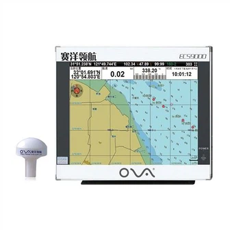
Product Introduction
Since the establishment of the company, we have accumulated a wealth of professional manufacturing technology and valuable experience through long-term research and exploration of nmea 0183 depth transducer, nmea 0183 depth transducer for sale, depth transducer marine. We have a complete after-sales service team to provide you with one-stop service to solve your worries. To improve the soft power and strengthen the construction of corporate culture has become a bridge for our company to enter the world market. Our company strives to reduce the cost, enhances the efficiency and strives to occupy the superiority in the market competition. We abide by the corporate spirit of steadfastness, hard work and responsibility to create a good corporate environment with integrity, win-win, and innovative business philosophy.
GPS marine chart plotters are widely used for navigation at sea, integrating electronic navigation charts with GPS data.
●Independent research and development of GPS receiver board, positioning accuracy, high stable speed and course
●Support GPS + Beidou Accurate positioning
Professional Grade Performance without the High End Price Tag
Marine GPS Waterproof Sunlight Viewable
Performance Parameter of the Gps Marine Chart Plotter
| |
Model | GBS9000-08 |
Power Supply | DC 24V(11~35V) |
Power Consumption | 15+1W |
Power | High-performance, full isolated PWM control of power supply |
Mount | Bracket Mount or Flush Mount |
Display Size | 8’’ |
Screen Resolution | 800*600px |
Language | Simple Chinese, English, Traditional Chinese |
Navigation Characteristics | |
Data Storage | Waypoints:6000;Marks:5000,Routes:200, 48 waypoints/Route Tracks≤800 (Track Points≤20000) |
Data Display | Suspension Data: Information of ship’s latitude, longitude, fish zone, speed, course; Navigation information of waypoints and routes; Time, date and so on. |
Other Functions | Tide and Compass Pages; AIS Display and Alarm, AIS Message, Vessel Management(if input AIS) |
GPS Characteristics | |
Receive Type | GPS/Glonass/Galileo/Beidou |
Receive Channel | GPS: 1575.42MHz(L1) Beidou: 1561.098MHz(L) |
Aquisition Time | Cold Start: 45s Hot Start: 15s |
Accuracy | GPS:<13m(95%) Beidou: Horizontal 25m(95%) Vertical 30m(95%) |
Interface | |
Input/Output | GPS/Beidou(GGA, GSA, GLL, GSV, RMC, VTG) |
Output | AIS(VDM) |
SD Card | Update software and chart, import and export data |


OVA gps marine chart plotter, Independent research and development of GPS receiver board, positioning accuracy, high stable speed and course.We have a wide range of products to meet your every Marine navigation need.
Our personnel are generally in the spirit of 'continuous improvement and excellence', and together with the outstanding top quality merchandise, favorable price tag and fantastic after-sales solutions, we try to gain every single customer's rely on for 10 Inch Chart Plotter with Automatic Identification System AIS 9000-10. We will strengthen the basic work of enterprise safety production and improve the technical specifications and quality work standards of safety production. Safety as a result of innovation is our promise to each other.
Hot Tags: gps marine chart plotter, manufacturers, suppliers, wholesale, custom, buy, best, price, on sale, for sale, ais marine gps chart plotter, automatic identification system for ship, marine sonar fish finder, boat gps navigation marine, nmea 0183 depth transducer for sale, nmea 0183 depth transducer
You Might Also Like
-

10" Marine True Color TFT LCD GPS AIS Navigator Chartplotter
-

Ova Marine Depth Echo Sounder Transducer 200kHz Transducer
-
Marine Shipping Equipment Marine Navigator AIS Chart Plotter
-
Geo Real Time Hidden Spy Mobile Cheap Easy Installation Mini GPS Car Tracker with Tamper Alarm
-

IP65/IP68 Stainless Steel Electronic Level Transducer with 4-20mA/0-10V/0-5V/Modbus Output
-
8" Marine Echo Depth Sounder with Transducer
Send Inquiry