
12-Inch 2W/5W/12.5W Output Power AIS Class B GPS Chart Plotter
MARINE gps marine chart plotter ●Independent research and development of GPS receiver board, positioning accuracy, high stable speed and course ●Support GPS + Beidou Accurate positioning Professional Grade Performance without the High End Price Tag Marine GPS Waterproof Sunlight Viewable OVA gps...
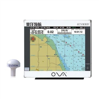
Product Introduction
We take strong technical force, high-quality products and perfect and thoughtful technical services as our unremitting and enterprising criteria. With high-quality, cohesive staff, superb manufacturing technology and complete processing and testing equipment, we produce transducer for fishfinder, nmea 0183 depth transducer, gps navigation for boat that satisfy customers. Our company insists on the tenet of striving for survival with quality and reputation as the foundation, and the service market is also gradually facing international. The scientificity, rationality and feasibility of enterprise development strategy play an important role in the sustainable development of our company.
GPS marine chart plotters are widely used for navigation at sea, integrating electronic navigation charts with GPS data.
●Independent research and development of GPS receiver board, positioning accuracy, high stable speed and course
●Support GPS + Beidou Accurate positioning
Professional Grade Performance without the High End Price Tag
Marine GPS Waterproof Sunlight Viewable
Performance Parameter of the Gps Marine Chart Plotter
| |
Model | GBS9000-08 |
Power Supply | DC 24V(11~35V) |
Power Consumption | 15+1W |
Power | High-performance, full isolated PWM control of power supply |
Mount | Bracket Mount or Flush Mount |
Display Size | 8’’ |
Screen Resolution | 800*600px |
Language | Simple Chinese, English, Traditional Chinese |
Navigation Characteristics | |
Data Storage | Waypoints:6000;Marks:5000,Routes:200, 48 waypoints/Route Tracks≤800 (Track Points≤20000) |
Data Display | Suspension Data: Information of ship’s latitude, longitude, fish zone, speed, course; Navigation information of waypoints and routes; Time, date and so on. |
Other Functions | Tide and Compass Pages; AIS Display and Alarm, AIS Message, Vessel Management(if input AIS) |
GPS Characteristics | |
Receive Type | GPS/Glonass/Galileo/Beidou |
Receive Channel | GPS: 1575.42MHz(L1) Beidou: 1561.098MHz(L) |
Aquisition Time | Cold Start: 45s Hot Start: 15s |
Accuracy | GPS:<13m(95%) Beidou: Horizontal 25m(95%) Vertical 30m(95%) |
Interface | |
Input/Output | GPS/Beidou(GGA, GSA, GLL, GSV, RMC, VTG) |
Output | AIS(VDM) |
SD Card | Update software and chart, import and export data |


OVA gps marine chart plotter, Independent research and development of GPS receiver board, positioning accuracy, high stable speed and course.We have a wide range of products to meet your every Marine navigation need.
In order to ensure the excellent quality of 12-Inch 2W/5W/12.5W Output Power AIS Class B GPS Chart Plotter, every employee of our company constantly improves their self-cultivation and strives for perfection in every link. Our company adopts modern scientific management methods to continuously enhance the overall quality and improve market adaptability. Our company insists on customer satisfaction as the center, and has formed a set of perfect and advanced service concept. It is our consistent purpose to help customers improve their core competitiveness.
Hot Tags: gps marine chart plotter, manufacturers, suppliers, wholesale, custom, buy, best, price, on sale, for sale, Stainless Steel Transducer, marine sonar fish finder, gps marine navigation, Gps Marine Chart Plotter, nmea 0183 depth transducer, GNSS COMPASS
You Might Also Like
-

Ova Marine Rubber Transducer a-Td33 Ultrasonic Sensor for Finding Fish
-

Easy to Use Fish Finder Bronze Underwater Ultrasonic Transducer
-
High Power Fish Finder Bronze Underwater Ultrasonic Transducer
-

Drone Fish Finder Underwater Video Camera with Bait Boat and Sonar Underwater Fishing Drone
-

IP65/IP68 Stainless Steel Electronic Level Transducer with 4-20mA/0-10V/0-5V/Modbus Output
-
Rudder Angle Indicators Marine Navigation Equiptment
Send Inquiry