
12 Inch 2W Output Power AIS Class B Waterproof GPS Chart Plotter
MARINE gps marine chart plotter ●Independent research and development of GPS receiver board, positioning accuracy, high stable speed and course ●Support GPS + Beidou Accurate positioning Professional Grade Performance without the High End Price Tag Marine GPS Waterproof Sunlight Viewable OVA gps...
Product Introduction
Relying on scientific research results, our company is specialized in the research and development, production and sales of various automatic identification system for ship, Stainless Steel Transducer, transducer supplier. Our company has introduced advanced production technology and process to meet the international standards. We use the double first concept of quality and service to realize the sustainable development of our company.
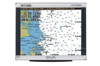
GPS marine chart plotters are widely used for navigation at sea, integrating electronic navigation charts with GPS data.
●Independent research and development of GPS receiver board, positioning accuracy, high stable speed and course
●Support GPS + Beidou Accurate positioning
Professional Grade Performance without the High End Price Tag
Marine GPS Waterproof Sunlight Viewable
Performance Parameter of the Gps Marine Chart Plotter
| |
Model | GBS9000-08 |
Power Supply | DC 24V(11~35V) |
Power Consumption | 15+1W |
Power | High-performance, full isolated PWM control of power supply |
Mount | Bracket Mount or Flush Mount |
Display Size | 8’’ |
Screen Resolution | 800*600px |
Language | Simple Chinese, English, Traditional Chinese |
Navigation Characteristics | |
Data Storage | Waypoints:6000;Marks:5000,Routes:200, 48 waypoints/Route Tracks≤800 (Track Points≤20000) |
Data Display | Suspension Data: Information of ship’s latitude, longitude, fish zone, speed, course; Navigation information of waypoints and routes; Time, date and so on. |
Other Functions | Tide and Compass Pages; AIS Display and Alarm, AIS Message, Vessel Management(if input AIS) |
GPS Characteristics | |
Receive Type | GPS/Glonass/Galileo/Beidou |
Receive Channel | GPS: 1575.42MHz(L1) Beidou: 1561.098MHz(L) |
Aquisition Time | Cold Start: 45s Hot Start: 15s |
Accuracy | GPS:<13m(95%) Beidou: Horizontal 25m(95%) Vertical 30m(95%) |
Interface | |
Input/Output | GPS/Beidou(GGA, GSA, GLL, GSV, RMC, VTG) |
Output | AIS(VDM) |
SD Card | Update software and chart, import and export data |


OVA gps marine chart plotter, Independent research and development of GPS receiver board, positioning accuracy, high stable speed and course.We have a wide range of products to meet your every Marine navigation need.
We use strict testing equipment to test the quality of products to ensure the standard of 12 Inch 2W Output Power AIS Class B Waterproof GPS Chart Plotter. Our company has gathered a number of excellent talents and trained a team with high level, excellent innovation spirit and outstanding business ability. Our products are mature, deeply loved by the majority of users, our market demand is huge, the prospect is broad.
Hot Tags: gps marine chart plotter, manufacturers, suppliers, wholesale, custom, buy, best, price, on sale, for sale, gps boat marine gps ais, gps marine navigation, transducers, gps navigation for boat, fishfinder chartplotter transducer, in hull depth transducer nmea 0183
You Might Also Like
-

50/200 kHz Plastic Marine Temperature Transducer
-

Rubber Ultrasonic Transducer for Fish Finder or Echo Sounder a-Tgm50-200-10L
-

12 Inch Aluminum China Marine GPS AIS Chart Plotter
-

Underwater Transducer Transmitter Receiver Fish Finder Echo Sounder Transducers
-
200kHz Underwater Ultrasonic Depth Transducer for Submarine Range Finder
-

10.4 Inches TFT LCD 50/200 kHz 600W Marine Navigation Echo Sounder Fish Finder
Send Inquiry