
Electronic Equipment Marine 8 Inch Ova GPS Marine AIS Chart Plotter
MARINE gps marine chart plotter ●Independent research and development of GPS receiver board, positioning accuracy, high stable speed and course ●Support GPS + Beidou Accurate positioning Professional Grade Performance without the High End Price Tag Marine GPS Waterproof Sunlight Viewable OVA gps...
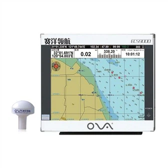
Product Introduction
We take the quality as the life, warmly welcome the new and old customers to choose our depth transducer nmea 0183, fishfinder chartplotter transducer, depth transducer marine, the cooperation will last forever. You will be satisfied with the service and products. We believe that respecting the rules and procedures and doing things right at one time is the best way to be responsible for efficiency. Base upon the presence and look into the future, we will continue to increase our investment and strengthen the management system. We treat each customer in accordance with the industry integrity, do not falsely report the product price, when the customer orders, we will grasp the production to ensure the construction period.
GPS marine chart plotters are widely used for navigation at sea, integrating electronic navigation charts with GPS data.
●Independent research and development of GPS receiver board, positioning accuracy, high stable speed and course
●Support GPS + Beidou Accurate positioning
Professional Grade Performance without the High End Price Tag
Marine GPS Waterproof Sunlight Viewable
Performance Parameter of the Gps Marine Chart Plotter
| |
Model | GBS9000-08 |
Power Supply | DC 24V(11~35V) |
Power Consumption | 15+1W |
Power | High-performance, full isolated PWM control of power supply |
Mount | Bracket Mount or Flush Mount |
Display Size | 8’’ |
Screen Resolution | 800*600px |
Language | Simple Chinese, English, Traditional Chinese |
Navigation Characteristics | |
Data Storage | Waypoints:6000;Marks:5000,Routes:200, 48 waypoints/Route Tracks≤800 (Track Points≤20000) |
Data Display | Suspension Data: Information of ship’s latitude, longitude, fish zone, speed, course; Navigation information of waypoints and routes; Time, date and so on. |
Other Functions | Tide and Compass Pages; AIS Display and Alarm, AIS Message, Vessel Management(if input AIS) |
GPS Characteristics | |
Receive Type | GPS/Glonass/Galileo/Beidou |
Receive Channel | GPS: 1575.42MHz(L1) Beidou: 1561.098MHz(L) |
Aquisition Time | Cold Start: 45s Hot Start: 15s |
Accuracy | GPS:<13m(95%) Beidou: Horizontal 25m(95%) Vertical 30m(95%) |
Interface | |
Input/Output | GPS/Beidou(GGA, GSA, GLL, GSV, RMC, VTG) |
Output | AIS(VDM) |
SD Card | Update software and chart, import and export data |


OVA gps marine chart plotter, Independent research and development of GPS receiver board, positioning accuracy, high stable speed and course.We have a wide range of products to meet your every Marine navigation need.
Meanwhile, our company staffs a team of experts devoted to the development of Electronic Equipment Marine 8 Inch Ova GPS Marine AIS Chart Plotter. Our company adheres to a fast, efficient, and low-cost service communication, which is based on honesty. Our goal is to minimize the total transportation and inventory costs of the supply chain with a given customer service level.
Hot Tags: gps marine chart plotter, manufacturers, suppliers, wholesale, custom, buy, best, price, on sale, for sale, gps boat marine gps ais, GNSS COMPASS, depth transducer marine, transducer for fishfinder, echo sounder transducer, underwater depth transducer
You Might Also Like
-

Ova 8 Inch Marine Ship AIS Receiver GPS Chart Plotter
-

a-Tgm50-200-10L Echo Sounder Fishfinder Transducer Boat
-

Siemens Ec9-4 Endovaginal Transducer|Antares Prostate|Dl-4 Connector|Original|New|Medical Supplier|Medical Imaging Equipment|Medical Imag...
-

Boat Compass Marine Electronics Nmea 0183 Satellite Compass for Sale
-
China Manufacturer Competitive Marine GPS Navigator AIS Chart Plotter
-
8 Inch Advanced Technology Marine GPS Chart Plotter
Send Inquiry