
GPS Marine Yacht Class B AIS Transponder for Ship
MARINE gps marine chart plotter ●Independent research and development of GPS receiver board, positioning accuracy, high stable speed and course ●Support GPS + Beidou Accurate positioning Professional Grade Performance without the High End Price Tag Marine GPS Waterproof Sunlight Viewable OVA gps...
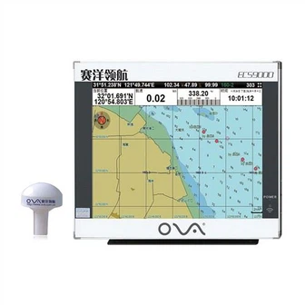
Product Introduction
On the basis of continuous improvement of product quality, we promote innovation, vigorously develop new products, and actively strive to provide consumers with better navigator marine electronics, SONAR SENSOR FISH FINDER, fishfinder chartplotter transducer solutions to meet their needs, so as to achieve a win-win situation between enterprises and users. So please make contact with us by sending us emails or call us when you've got any questions about our organization. We sincerely welcome overseas customers to consult for the long-term cooperation and the mutual development. In response to market demand at home and abroad, our company has developed a variety of production lines and related equipment to meet the needs of different customers.
GPS marine chart plotters are widely used for navigation at sea, integrating electronic navigation charts with GPS data.
●Independent research and development of GPS receiver board, positioning accuracy, high stable speed and course
●Support GPS + Beidou Accurate positioning
Professional Grade Performance without the High End Price Tag
Marine GPS Waterproof Sunlight Viewable
Performance Parameter of the Gps Marine Chart Plotter
| |
Model | GBS9000-08 |
Power Supply | DC 24V(11~35V) |
Power Consumption | 15+1W |
Power | High-performance, full isolated PWM control of power supply |
Mount | Bracket Mount or Flush Mount |
Display Size | 8’’ |
Screen Resolution | 800*600px |
Language | Simple Chinese, English, Traditional Chinese |
Navigation Characteristics | |
Data Storage | Waypoints:6000;Marks:5000,Routes:200, 48 waypoints/Route Tracks≤800 (Track Points≤20000) |
Data Display | Suspension Data: Information of ship’s latitude, longitude, fish zone, speed, course; Navigation information of waypoints and routes; Time, date and so on. |
Other Functions | Tide and Compass Pages; AIS Display and Alarm, AIS Message, Vessel Management(if input AIS) |
GPS Characteristics | |
Receive Type | GPS/Glonass/Galileo/Beidou |
Receive Channel | GPS: 1575.42MHz(L1) Beidou: 1561.098MHz(L) |
Aquisition Time | Cold Start: 45s Hot Start: 15s |
Accuracy | GPS:<13m(95%) Beidou: Horizontal 25m(95%) Vertical 30m(95%) |
Interface | |
Input/Output | GPS/Beidou(GGA, GSA, GLL, GSV, RMC, VTG) |
Output | AIS(VDM) |
SD Card | Update software and chart, import and export data |


OVA gps marine chart plotter, Independent research and development of GPS receiver board, positioning accuracy, high stable speed and course.We have a wide range of products to meet your every Marine navigation need.
Our firm since its inception, normally regards item top quality as company life, constantly make improvements to generation technology, improve product excellent and repeatedly strengthen organization total good quality management, in strict accordance with the national standard ISO 9001:2000 for GPS Marine Yacht Class B AIS Transponder for Ship. Our company has an experienced after-sales service team and an improved system for providing efficient service. We always carry a sense of responsibility for every product and every user. We are well aware that development is the eternal theme of the enterprise and the first priority of the enterprise.
Hot Tags: gps marine chart plotter, manufacturers, suppliers, wholesale, custom, buy, best, price, on sale, for sale, Gps Marine Chart Plotter, ova marine rubber transducer, depth sounder transducer, marine fishing navigator, marine sonar fish finder, gps marine navigation
You Might Also Like
-
High Resolution Continuous Sampling 12inch Marine GPS Navigator
-

17" AIS Colorful Transponder GPS Chart Plotter for Sale
-

Water-Proof Stainless Steel Submersible Water Level Transducer
-
SCP12030LCD 120V 30A Factory Price Solar Charge Controller off Grid System
-
Marine Automatic AIS Class B Transponder
-

Easy Business Sale on Professional Mode Fishfinder GPS
Send Inquiry