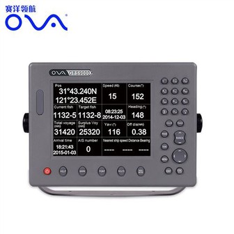
Marine Chart Plotter GPS Navigator for Fishing
Marine gps navigator with chartplotter, 17 Inch Dual System Marine Electronics Chart Plotter System Product performance ● The electronic sea map is including global map, supporting vector map IHO,S57,S63 and RNC raster sea chart ● Flexible expandability and many navigation sensor interfaces...
Product Introduction
Our Stainless Steel Transducer, depth transducer nmea 0183, ais gps chartplotter has extremely excellent performance and exquisite workmanship because of the standardized production base, advanced production equipment, modern enterprise management mode, procedural and strict quality monitoring system. Our company has a high level of project management, keen vision, seize the market opportunity to win our own development and growth. Our company is in line with the 'customer first, quality-oriented' principle, we have established and improved the strict quality standard inspection system.We will solve your worries with sincere service and real quality.
GPS marine navigation with chartplotter, 17 Inch Dual System Marine Electronics Chart Plotter System
Product performance
●The electronic sea map is including global map, supporting vector map IHO,S57,S63 and RNC raster sea chart
●Flexible expandability and many navigation sensor interfaces allow the ECS to be networked with AIS,GPS,Echo Sounder,Compass,Log,ARPA and others to consolidate the navigation system
●17 inch industrial display screen provides high resolution of 1280x1024
●The electronic chart can be overlaid with a variety of navigation data such as ship’s position, heading,speed and others to facilitate safe and efficient navigation
●Navigation data for the past 12 hours can be recorded and playback
●CERTIFICATED by China Classification Society
●CERTIFICATED by Register of Fishing Vessel of The People’s Republic of China
Technical Specification:
Model | ECS9000 |
 | |
Power Supply | DC24V(16-35V) |
Power | High-performance, full isolated, PWM control of power supply |
Installation | Desk,Bracket or Embedded |
Display Unit | |
Type | 17” |
Screen Resolution | 1280*1024px |
Language | Simplified Chinese, English |
Characteristics | |
Chart Format | IHO S57,S63(ENC),RNC |
Display Modes | North-Up、SouthUp、Route-Up、Head-Up |
Display of Data | Own ship:Position,COG,SOG,Heading; Others:Cursor Data、Target information、Navigation、EBL、VRM |
Route/Waypoint | Routes≥100;Waypoints≥5000 |
Alarm | Off track,Communication,Position,Collision,Alert area,Hazardous material |
Voyage Calculation | Range/Bearing to Destination,Off track,TTG,ETA |
Navigation Log | ≥12h |
Track Display | ≥240min |
Other Functions | Measurement(Distance,Bearing,CPA/TCPA),User chart function,Log book,Night/day presentation colors,ARPA target display |
Interface | |
Input/Output | GPS(GGA,GLL,GSA,GSV,RMC,VTG) |
Input | AIS(VDM,ABM,BBM),compass(HDT),Speed log(VBM), Echo Sounder(DBT,DPT),Water temp Indicator(MTW), Anemometer(MWV),Current Indicator(VDR) |


We could customize the marine GPS chart plotter with multilingual, and our gps marine navigation adopt Windows operating system. GPS marine navigation with chartplotter, Electronic Chart System can cover all kinds of navigation data, it can connect with ECS, AIS, GPS, Echo Sounder, Compass, Speed Log, ARPA and other devices to support more stable navigation system.
We are a manufacturer for Marine Chart Plotter GPS Navigator for Fishing that you can always trust. Value concept is the core and soul of corporate culture, our company actively cultivates the core value concept and guides all employees to identify with and consciously pursue the core value concept, which is also an important task to strengthen the construction of corporate culture. The core value of our enterprise is to create value for customers, career for employees and benefit for society.
Hot Tags: gps marine navigation, manufacturers, suppliers, wholesale, custom, buy, best, price, on sale, for sale, professional fish finder, gps marine navigation, Gps Marine Chart Plotter, depth transducer nmea 0183, ova marine rubber transducer, automatic identification system for ship
You Might Also Like
-

High Quality Navigation GPS Marine AIS Chart Plotter for Fishing Boat
-

The Legendary Reputation Lucky 180m Depth Fishing Finder
-

CL2E-KMC456 Comlom Inclinometer Multifunction Outdoor Navigation Map Compass
-

GPS AIS Class B Transceiver Vessel Tracking Transponder
-

600W Remote Control Wireless GPS Fish Finder Marine
-

Ova 10 Inches Underwater Professional Fish Finder
Send Inquiry
