
Marine GPS Combo AIS Class B Ship GPS Navigator
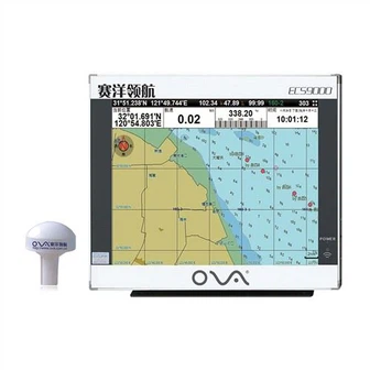
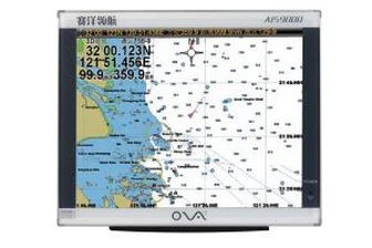
Marine gps navigator with chartplotter, 17 Inch Dual System Marine Electronics Chart Plotter System Product performance ● The electronic sea map is including global map, supporting vector map IHO,S57,S63 and RNC raster sea chart ● Flexible expandability and many navigation sensor interfaces...
Product Introduction
We have been a stable and reliable supplier of BOAT SONAR FISH FINDER, marine fishing navigator, nmea 0183 depth transducer on the market with our rich experience and continuous innovation technology. The items to assure years of trouble-free service has attracted a great deal customers. With increasing competition in the market, more and more companies have improved their competitiveness with high-quality, personalized products and services. Our pursuit and enterprise aim would be to 'Always fulfill our buyer requirements'. Our friendship with customers is based on mutual respect, equality and mutual benefit.
GPS marine navigation with chartplotter, 17 Inch Dual System Marine Electronics Chart Plotter System
Product performance
●The electronic sea map is including global map, supporting vector map IHO,S57,S63 and RNC raster sea chart
●Flexible expandability and many navigation sensor interfaces allow the ECS to be networked with AIS,GPS,Echo Sounder,Compass,Log,ARPA and others to consolidate the navigation system
●17 inch industrial display screen provides high resolution of 1280x1024
●The electronic chart can be overlaid with a variety of navigation data such as ship’s position, heading,speed and others to facilitate safe and efficient navigation
●Navigation data for the past 12 hours can be recorded and playback
●CERTIFICATED by China Classification Society
●CERTIFICATED by Register of Fishing Vessel of The People’s Republic of China
Technical Specification:
Model | ECS9000 |
 | |
Power Supply | DC24V(16-35V) |
Power | High-performance, full isolated, PWM control of power supply |
Installation | Desk,Bracket or Embedded |
Display Unit | |
Type | 17” |
Screen Resolution | 1280*1024px |
Language | Simplified Chinese, English |
Characteristics | |
Chart Format | IHO S57,S63(ENC),RNC |
Display Modes | North-Up、SouthUp、Route-Up、Head-Up |
Display of Data | Own ship:Position,COG,SOG,Heading; Others:Cursor Data、Target information、Navigation、EBL、VRM |
Route/Waypoint | Routes≥100;Waypoints≥5000 |
Alarm | Off track,Communication,Position,Collision,Alert area,Hazardous material |
Voyage Calculation | Range/Bearing to Destination,Off track,TTG,ETA |
Navigation Log | ≥12h |
Track Display | ≥240min |
Other Functions | Measurement(Distance,Bearing,CPA/TCPA),User chart function,Log book,Night/day presentation colors,ARPA target display |
Interface | |
Input/Output | GPS(GGA,GLL,GSA,GSV,RMC,VTG) |
Input | AIS(VDM,ABM,BBM),compass(HDT),Speed log(VBM), Echo Sounder(DBT,DPT),Water temp Indicator(MTW), Anemometer(MWV),Current Indicator(VDR) |


We could customize the marine GPS chart plotter with multilingual, and our gps marine navigation adopt Windows operating system. GPS marine navigation with chartplotter, Electronic Chart System can cover all kinds of navigation data, it can connect with ECS, AIS, GPS, Echo Sounder, Compass, Speed Log, ARPA and other devices to support more stable navigation system.
We are committed to maintaining the high quality of our Marine GPS Combo AIS Class B Ship GPS Navigator from beginning to end and continuing to innovate and create greater value for our customers. What we can achieve is because no one takes the cause of intelligent technology more seriously and seriously than us! We always adhere to the management policy of "establishing the brand by quality and occupying the market by leading technology".
Hot Tags: gps marine navigation, manufacturers, suppliers, wholesale, custom, buy, best, price, on sale, for sale, boat gps marine gps navigator, ova marine rubber transducer, 1kw transducer, in hull depth transducer nmea 0183, SONAR SENSOR FISH FINDER, nmea0183 echo sounder ultrasonic transducer
You Might Also Like
-

a-Td33 1.5kw Rubber Underwater Ultrasonic Transducer for Hondex Fishfinder
-

Siemens Ec9-4 Endovaginal Transducer|Antares Prostate|Dl-4 Connector|Original|New|Medical Supplier|Medical Imaging Equipment|Medical Imag...
-
Personal Epirb Beacon Hiking Emergency Locator
-

PWM Controller 60A 48 Volt Solar Panel System
-
60A PWM Renewable Energy Solar Charge Controller Solar Energy Systems Home
-
200kHz Underwater Ultrasonic Transducer for 120m Depth Measurement
Send Inquiry