
Ova 12 Inch Marine AIS Transponder & GPS Chart Plotter Ship Navigator
MARINE gps marine chart plotter ●Independent research and development of GPS receiver board, positioning accuracy, high stable speed and course ●Support GPS + Beidou Accurate positioning Professional Grade Performance without the High End Price Tag Marine GPS Waterproof Sunlight Viewable OVA gps...
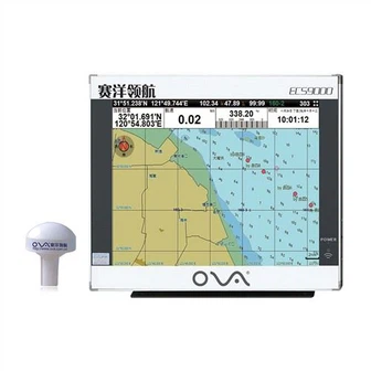
Product Introduction
Our underwater depth transducer, fishfinder chartplotter transducer, echo sounder transducer has been recognized by customers around the globe for its outstanding performance, durability and ease of use. We should turn dreams into reality, turn ideals into actions, regard failure as a test and success as an incentive. We adhere to the principle of 'low cost, high quality', do everything with our heart, and take action to prove that your choice is wise. It is more important for us: adhere to long-term cooperation with you is our goal from beginning to end.
GPS marine chart plotters are widely used for navigation at sea, integrating electronic navigation charts with GPS data.
●Independent research and development of GPS receiver board, positioning accuracy, high stable speed and course
●Support GPS + Beidou Accurate positioning
Professional Grade Performance without the High End Price Tag
Marine GPS Waterproof Sunlight Viewable
Performance Parameter of the Gps Marine Chart Plotter
| |
Model | GBS9000-08 |
Power Supply | DC 24V(11~35V) |
Power Consumption | 15+1W |
Power | High-performance, full isolated PWM control of power supply |
Mount | Bracket Mount or Flush Mount |
Display Size | 8’’ |
Screen Resolution | 800*600px |
Language | Simple Chinese, English, Traditional Chinese |
Navigation Characteristics | |
Data Storage | Waypoints:6000;Marks:5000,Routes:200, 48 waypoints/Route Tracks≤800 (Track Points≤20000) |
Data Display | Suspension Data: Information of ship’s latitude, longitude, fish zone, speed, course; Navigation information of waypoints and routes; Time, date and so on. |
Other Functions | Tide and Compass Pages; AIS Display and Alarm, AIS Message, Vessel Management(if input AIS) |
GPS Characteristics | |
Receive Type | GPS/Glonass/Galileo/Beidou |
Receive Channel | GPS: 1575.42MHz(L1) Beidou: 1561.098MHz(L) |
Aquisition Time | Cold Start: 45s Hot Start: 15s |
Accuracy | GPS:<13m(95%) Beidou: Horizontal 25m(95%) Vertical 30m(95%) |
Interface | |
Input/Output | GPS/Beidou(GGA, GSA, GLL, GSV, RMC, VTG) |
Output | AIS(VDM) |
SD Card | Update software and chart, import and export data |


OVA gps marine chart plotter, Independent research and development of GPS receiver board, positioning accuracy, high stable speed and course.We have a wide range of products to meet your every Marine navigation need.
Often customer-oriented, and it's our ultimate target to become not only probably the most reputable, trustable and honest provider, but also the partner for Ova 12 Inch Marine AIS Transponder & GPS Chart Plotter Ship Navigator. By acting quickly to meet your requirements, we can provide all possible related services, including but not limited to design, production, delivery and after-sales service. Our company has strong strength, attaches great importance to credit, abides by the contract, ensures the product quality and wins the trust of customers with the principle of diversified business characteristics and small profit and high sales.
Hot Tags: gps marine chart plotter, manufacturers, suppliers, wholesale, custom, buy, best, price, on sale, for sale, automatic identification system for ship, marine transducers, navigator marine electronics, boat gps marine gps navigator, marine gps navigator, echo sounder transducer fish finder transducer
You Might Also Like
-

600W 50/200kHz Plastic Through Hull Nmea 0183 Transducer
-

Ova Marine 15 Inch Deeper GPS Fishing Boat Fish Finder
-

Navigation System Ova Marine GPS Chartplotters
-

1kw 200kHz Fish Finder/ Echo Sounder Ultrasonic Transducer
-

Great Will At3 Magnet Wireless GPS GSM Tracker Vehicle Boat Container GPS Tracker
-
New 8 Inch Marine Navigational Equipment GPS Navigator for Boat
Send Inquiry