
Ships and Marine Equipment GPS Marine Chart Plotter Navigation
MARINE gps marine chart plotter ●Independent research and development of GPS receiver board, positioning accuracy, high stable speed and course ●Support GPS + Beidou Accurate positioning Professional Grade Performance without the High End Price Tag Marine GPS Waterproof Sunlight Viewable OVA gps...
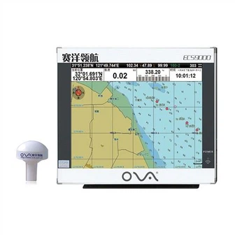
Product Introduction
With exquisite craftsmanship and specialized design, we have created more and more perfect gps marine navigation, Marine Boat Depth Transducer, Satellite Compass to offer better product for our customers. We strengthen the incentive and restraint mechanism and further improve the statutory basis and policy environment for operation, providing the foundation and basis for sound operation. We give full encouragement to all the strivers, and hope to form a good atmosphere of motivation. After years of development, a full range of product coverage system has been realized.
GPS marine chart plotters are widely used for navigation at sea, integrating electronic navigation charts with GPS data.
●Independent research and development of GPS receiver board, positioning accuracy, high stable speed and course
●Support GPS + Beidou Accurate positioning
Professional Grade Performance without the High End Price Tag
Marine GPS Waterproof Sunlight Viewable
Performance Parameter of the Gps Marine Chart Plotter
| |
Model | GBS9000-08 |
Power Supply | DC 24V(11~35V) |
Power Consumption | 15+1W |
Power | High-performance, full isolated PWM control of power supply |
Mount | Bracket Mount or Flush Mount |
Display Size | 8’’ |
Screen Resolution | 800*600px |
Language | Simple Chinese, English, Traditional Chinese |
Navigation Characteristics | |
Data Storage | Waypoints:6000;Marks:5000,Routes:200, 48 waypoints/Route Tracks≤800 (Track Points≤20000) |
Data Display | Suspension Data: Information of ship’s latitude, longitude, fish zone, speed, course; Navigation information of waypoints and routes; Time, date and so on. |
Other Functions | Tide and Compass Pages; AIS Display and Alarm, AIS Message, Vessel Management(if input AIS) |
GPS Characteristics | |
Receive Type | GPS/Glonass/Galileo/Beidou |
Receive Channel | GPS: 1575.42MHz(L1) Beidou: 1561.098MHz(L) |
Aquisition Time | Cold Start: 45s Hot Start: 15s |
Accuracy | GPS:<13m(95%) Beidou: Horizontal 25m(95%) Vertical 30m(95%) |
Interface | |
Input/Output | GPS/Beidou(GGA, GSA, GLL, GSV, RMC, VTG) |
Output | AIS(VDM) |
SD Card | Update software and chart, import and export data |


OVA gps marine chart plotter, Independent research and development of GPS receiver board, positioning accuracy, high stable speed and course.We have a wide range of products to meet your every Marine navigation need.
We carefully create our own features of Ships and Marine Equipment GPS Marine Chart Plotter Navigation, and at the same time always insist on independent research and development in product concepts, supplemented by learning from others. Thus far, our item may be shown in most foreign nations as well as urban centers, which are sought after simply by targeted traffic. Our company strengthens its competitive position in the most valuable links, changes its growth mode and innovates its business model.
Hot Tags: gps marine chart plotter, manufacturers, suppliers, wholesale, custom, buy, best, price, on sale, for sale, depth transducer marine, marine gps navigator, depth transducer nmea 0183, 0183 transducer, BOAT SONAR FISH FINDER, transducer for fishfinder
You Might Also Like
-

Ova Marine 15 Inch Deeper GPS Fishing Boat Fish Finder
-

Siemens Ec9-4 Endovaginal Transducer|Antares Prostate|Dl-4 Connector|Original|New|Medical Supplier|Medical Imaging Equipment|Medical Imag...
-

Digital Satellite Signal Meter Finder Dish W Compass (2020)
-

G1/4 Male Thread Digital Pressure Transducer with RS485 Stainless Steel Steam Pressure Sensor
-

Ova Marine 15-Inch Deeper Fish Finder GPS Sonar for Fishing
-
Fish Finder (FS1001B)
Send Inquiry