Satellite & Doppler Speed Log Systems: The Backbone Of Precision Maritime Navigation
Satellite & Doppler Speed Log Systems: The Backbone of Precision Maritime Navigation
Satellite and Doppler Speed Log System stands as the gold standard, merging two powerful technologies to deliver unmatched precision, reliability, and operational insight for vessels of all types and sizes.
Understanding the Core: Two Technologies, One Unified Solution
At its heart, a combined Satellite and Doppler Speed Log System integrates two distinct, yet complementary, methods of speed measurement. This fusion creates a robust solution that excels where single-technology systems often fall short.
The Doppler Speed Log: Measuring Speed Through Water (STW)
The Doppler component operates on the well-established Doppler Effect. Mounted externally to the ship's hull, a transducer emits high-frequency acoustic pulses (typically ultrasound) at a known angle towards the seabed or the surrounding water column. As the ship moves, these sound waves bounce off the seabed or suspended particles in the water and reflect back to the transducer.
The motion of the vessel causes a measurable shift in the frequency of the returning sound waves. By calculating this frequency difference, the system's processor precisely determines the Speed Through Water (STW). This measurement is immune to surface currents and is vital for maneuvering in tight channels, docking, and collision avoidance. Modern Doppler systems boast impressive accuracy, often within ±0.2 knots or 2% of the actual speed, even in rough sea conditions. Advanced models also feature built-in sensors to compensate for water temperature, pressure, and even air bubbles that can temporarily disrupt the acoustic signal.
The Satellite Speed Log: Measuring Speed Over Ground (SOG)
While the Doppler system excels at measuring speed relative to the water, the satellite (GNSS/GPS)component tracks the vessel's absolute Speed Over Ground (SOG). By continuously receiving and triangulating signals from a constellation of global navigation satellites, the system calculates the ship's exact geographic position in real-time. By comparing successive position fixes, it derives the vessel's speed and direction of movement across the Earth's surface.
This data is indispensable for voyage planning, fuel efficiency optimization, and complying with international reporting regulations. Unlike terrestrial radio navigation, satellite signals provide global coverage, working seamlessly across oceans, polar regions, and remote areas where other signals fail.
Why a Combined System? The Unmatched Advantages
The true power lies in synergy. Relying solely on satellite navigation leaves a critical blind spot: it cannot distinguish between the ship's engine power and the influence of ocean currents. A ship could be moving at 15 knots through the water, but a 2-knot current could mean it's only making 13 knots over ground. Conversely, a Doppler system alone cannot account for these currents, leading to inaccurate estimated times of arrival (ETAs).
A combined Satellite & Doppler System solves this by providing both critical measurements simultaneously:
Complete Navigational Picture: Crews instantly access both STW and SOG, allowing for immediate assessment of current strength and direction. This is crucial for safe navigation and precise maneuvering.
Uninterrupted Redundancy: If one sensor is compromised (e.g., the transducer is fouled or satellite signals are temporarily jammed), the other provides a reliable backup, ensuring no loss of critical speed data.
Compliance with Maritime Regulations: International SOLAS conventions mandate that large commercial vessels carry equipment capable of measuring both water-referenced and ground-referenced speeds. A combined system fulfills this requirement with a single, integrated solution.
Enhanced Operational Efficiency: Access to precise dual-speed data enables masters and engineers to optimize engine performance, analyze fuel consumption patterns, and plan more efficient routes, directly impacting operational costs.
Seamless Integration: Modern systems are designed for easy integration with the ship's Integrated Bridge System (IBS), Electronic Chart Display and Information System (ECDIS), and other on-board sensors, creating a unified and intuitive navigational workspace.
Key Features of Modern High-Performance Systems
Today's top-tier Satellite and Doppler Speed Log Systems are far more than just speedometers. They are sophisticated data hubs packed with features tailored for the demanding marine environment:
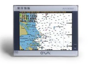
High-Resolution Touch Displays: Intuitive 7.0-inch or 4.0-inch high-precision color touchscreens present STW, SOG, and cumulative distance data clearly, even in direct sunlight or low-light conditions.
Robust Hardware: Transducers are built to withstand extreme water pressure, corrosion, and physical impact, often with options for protective fairings or sea chest installations.
Flexible Configuration: Offer a range of optional accessories, including remote display units for the bridge wing or engine control room, dedicated data processing units, and specialized mounting hardware.
Advanced Data Output: Provide digital and analog outputs to seamlessly feed critical data to other on-board systems, from autopilots to voyage data recorders.
Self-Diagnostic Alarms: Continuous built-in self-testing monitors system health and alerts the crew to any anomalies, such as transducer fouling or signal loss, ensuring maximum uptime.
The Future of Speed Measurement: Smart, Connected, and Even More Precise
The maritime industry is undergoing a digital transformation, and speed log technology is advancing in step. The future points towards smart sensors with AI-enhanced signal processing to further refine accuracy in challenging conditions like shallow water or high seas. We are also seeing greater connectivity, with these systems becoming integral parts of a ship's IoT ecosystem, feeding real-time performance data to shore-based management teams for predictive maintenance and fleet optimization.
In conclusion, the Satellite and Doppler Speed Log System is an indispensable piece of marine electronic equipment. It represents a perfect blend of proven acoustic technology and cutting-edge satellite navigation, delivering the precision, reliability, and redundancy that modern maritime operations demand. For shipowners, shipyards, and navigators alike, investing in a high-quality combined speed log system isn't just an upgrade-it's a fundamental step towards safer, more efficient, and more compliant voyages on every journey across the world's oceans.