



Gps Satellite Marine Navigator
Introduction to gps satellite marine navigator GPS satellite marine navigator is a crucial component for navigation and safety on board ships. One of the most advanced systems is the Beidou GPS dual-star system, which offers faster and more precise positioning. Its advanced speed and direction...
Product Introduction
Introduction to gps satellite marine navigator
GPS satellite marine navigator is a crucial component for navigation and safety on board ships. One of the most advanced systems is the Beidou GPS dual-star system, which offers faster and more precise positioning. Its advanced speed and direction filtering technology ensures smoother data, making it ideal not only for navigation but also for radar plotting, autopilots, fishfinders, and sonar.
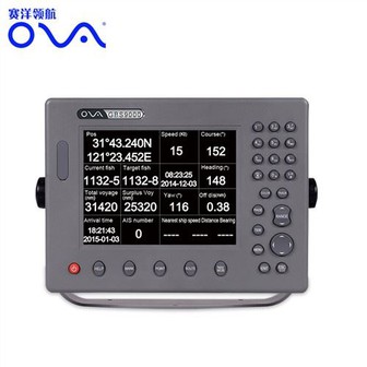
This GPS satellite marine navigator provides highly accurate ship motion information with multiple NMEA0183 outputs. Equipped with a 7-inch high-definition color display screen, it supports various display modes, making data more intuitive and convenient. Its
outstanding industrial product design not only gives it a stylish appearance but also makes it easy to install with low maintenance.
The advanced technology can withstand complex sea conditions, including strong wind, storms, and rough seas. These benefits make it an ideal tool for mariners and ship owners who require high-quality and reliable navigation systems.
In summary, the GPS satellite marine navigator is an excellent investment for mariners seeking the highest level of safety and navigation accuracy; with its fast and precise positioning, advanced speed filtering technology, and multiple output features, it helps make marine navigation much more efficient and reliable.
SYSTEM DIAGRAM
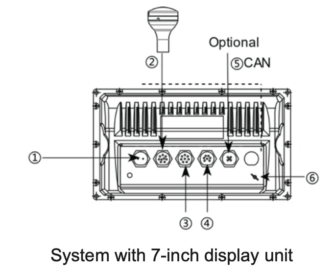
1 Power: 11~36V (1.DC+ 2.DC-);
2 Antenna unit: Internal wiring, please use the equipped 20m cable to connect;
3 NMEA 0183 Data: Standard IEC 61162-1 Digital Signal Outputs
(1.COM2 TX+ RS422 2.COM2 TX- RS422 3. COM2 TX+ RS422 4.COM2 TX- RS422) (5.COM2 TX+ RS422 6.COM2 TX- RS422 7.COM2 RX+ RTCM IN 8.COM2 RX- RTCM IN)
4 Alarm: Alarm digital two-way interaction and normally closed and outputs
(1.COM4 TX+ RS422 2.COM4 TX- RS422 3. COM4 RX+ RS422 4.COM4 RX- RS422 5.Alarm COM 6.Alarm N.C 7.GND )
6 Input Power:12V (1.SHIELD 2.12V 3.GND 4.NC 5.NC)
7 Digital inputs and outputs with alarms:
(1.COM4 TX+ RS422 2.COM4 TX- RS422 3. COM2 TX+ RS422 4.COM2 TX- RS422 5. COM2 RX+ RTCM IN 6. COM2 RX- RTCM IN 7. Alarm COM 8.Alarm N.C )
PACKING LIST
1) Main unit;
2) Antenna x 1;
3) 7Pin data cable x 1;
4) 8Pin data cable x 1;
5) 9Pin data cable(20m)x 1;
6) 2Pin power cable
7) Fuse x 5;
8) M3*25 Screws;
9) M4*20 Screws
10) Ear Nut x 2;
11) Mounting bracket;
12) Hoop clamp x 2;
13) Antenna Seal x 1;
14) Antenna Mounting Bottom Shell
15) Operation Manual;
16) Certificate of conformity andccs certificate
Technical parameters:
|
Model |
GP9000/GN900 |
|
Power Supply |
DC 24V(11~35V) |
| Accuracy Position | 3m (95%) |
| Receiver Sensitivity accuracy | -140dBm |
| RX Frequency | BDS:B1I:1561.098MHz GPS:L1 1575.42MHz GLonass: G11602.916MHz |
| Compass Safe Distance | Stand Compass:85cm Steering Compass:95cm |
| Degree of Protection of Enclosure | Antenna Unit:IP56 Display unit:IP20 |
Hot Tags: gps satellite marine navigator, manufacturers, suppliers, wholesale, custom, buy, best, price, on sale, for sale, boat gps navigation marine, chart plotter marine gps navigator, Gps Marine Chart Plotter, gps marine navigation, gps navigation for boat
You Might Also Like



Send Inquiry
