


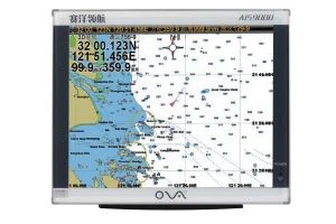
17 Inches LCD Ship AIS Chart Plotter for Boat
MARINE gps marine chart plotter ●Independent research and development of GPS receiver board, positioning accuracy, high stable speed and course ●Support GPS + Beidou Accurate positioning Professional Grade Performance without the High End Price Tag Marine GPS Waterproof Sunlight Viewable OVA gps...
Product Introduction
Our company always adheres to the management principle of talent oriented and integrity, gathers elites in the industry, combines our depth transducer nmea 0183, Marine Transducer 200khz, marine gps navigator with chartplotter with information technology, and provides excellent products and services for the majority of users. Our company attaches great importance to marketing strategy, ideological innovation and target innovation. We uphold the corporate philosophy of 'symbiosis', and our goal is creating world-class products, developing towards diversification and globalization. Over the years, our company has always been at the forefront of the industry in terms of economic benefits, social benefits and comprehensive strength.
GPS marine chart plotters are widely used for navigation at sea, integrating electronic navigation charts with GPS data.
●Independent research and development of GPS receiver board, positioning accuracy, high stable speed and course
●Support GPS + Beidou Accurate positioning
Professional Grade Performance without the High End Price Tag
Marine GPS Waterproof Sunlight Viewable
Performance Parameter of the Gps Marine Chart Plotter
| |
Model | GBS9000-08 |
Power Supply | DC 24V(11~35V) |
Power Consumption | 15+1W |
Power | High-performance, full isolated PWM control of power supply |
Mount | Bracket Mount or Flush Mount |
Display Size | 8’’ |
Screen Resolution | 800*600px |
Language | Simple Chinese, English, Traditional Chinese |
Navigation Characteristics | |
Data Storage | Waypoints:6000;Marks:5000,Routes:200, 48 waypoints/Route Tracks≤800 (Track Points≤20000) |
Data Display | Suspension Data: Information of ship’s latitude, longitude, fish zone, speed, course; Navigation information of waypoints and routes; Time, date and so on. |
Other Functions | Tide and Compass Pages; AIS Display and Alarm, AIS Message, Vessel Management(if input AIS) |
GPS Characteristics | |
Receive Type | GPS/Glonass/Galileo/Beidou |
Receive Channel | GPS: 1575.42MHz(L1) Beidou: 1561.098MHz(L) |
Aquisition Time | Cold Start: 45s Hot Start: 15s |
Accuracy | GPS:<13m(95%) Beidou: Horizontal 25m(95%) Vertical 30m(95%) |
Interface | |
Input/Output | GPS/Beidou(GGA, GSA, GLL, GSV, RMC, VTG) |
Output | AIS(VDM) |
SD Card | Update software and chart, import and export data |


OVA gps marine chart plotter, Independent research and development of GPS receiver board, positioning accuracy, high stable speed and course.We have a wide range of products to meet your every Marine navigation need.
Many years of experience in the import and export of 17 Inches LCD Ship AIS Chart Plotter for Boat has laid the foundation for our understanding of domestic and foreign product standards and quality. We stick to the spirit of pragmatic and innovative enterprise. Our company has always been flexible and we are open to different opportunities and situations.
Hot Tags: gps marine chart plotter, manufacturers, suppliers, wholesale, custom, buy, best, price, on sale, for sale, nmea 0183 depth transducer for sale, boat transducer, transducer for fishfinder, depth transducer marine, fishfinder chartplotter transducer, marine gps navigator
You Might Also Like
-

Marine Ultrasonic Transducer Nmea0183 Fish Finder Transducer
-

China Manufactory 600W 50/200kHz Depth Fish Finder Sonar Echo Sounder for Boat
-

2021 Hot Selling Model 22 Hours Working Time Fish Finder
-
Factory Customization Sonar Fishfinder for Entry
-

1MHz Stainless Steel Ultrasonic Transducer for Flow Meter Sensor
-
105kHz Underwater Ultrasonic Depth Transducer for Ultrasonic Flowmeter
Send Inquiry