
19" Ship Navigation Equipment Marine AIS GPS Chart Plotter
MARINE gps marine chart plotter ●Independent research and development of GPS receiver board, positioning accuracy, high stable speed and course ●Support GPS + Beidou Accurate positioning Professional Grade Performance without the High End Price Tag Marine GPS Waterproof Sunlight Viewable OVA gps...
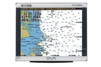
Product Introduction
We are confident that our quality ova marine rubber transducer, 1kw transducer, marine sonar fish finder will be the best choice for our customers to enhance their brand image. Layer by layer, we strive to give our best products and services to customers, welcome the majority of businesses to call and inquire. The introduction and absorption of advanced technology, is the only way to accelerate enterprise development and cultivate independent R&D capacity. We always follow the principle of good quality and customer first to vigorously develop glass production, and we are willing to develop together with customers at home and abroad to create a harmonious and beautiful future! Our company has been continuously introducing advanced production equipment, tapping high level technicians and cultivating an experienced technical team.
GPS marine chart plotters are widely used for navigation at sea, integrating electronic navigation charts with GPS data.
●Independent research and development of GPS receiver board, positioning accuracy, high stable speed and course
●Support GPS + Beidou Accurate positioning
Professional Grade Performance without the High End Price Tag
Marine GPS Waterproof Sunlight Viewable
Performance Parameter of the Gps Marine Chart Plotter
| |
Model | GBS9000-08 |
Power Supply | DC 24V(11~35V) |
Power Consumption | 15+1W |
Power | High-performance, full isolated PWM control of power supply |
Mount | Bracket Mount or Flush Mount |
Display Size | 8’’ |
Screen Resolution | 800*600px |
Language | Simple Chinese, English, Traditional Chinese |
Navigation Characteristics | |
Data Storage | Waypoints:6000;Marks:5000,Routes:200, 48 waypoints/Route Tracks≤800 (Track Points≤20000) |
Data Display | Suspension Data: Information of ship’s latitude, longitude, fish zone, speed, course; Navigation information of waypoints and routes; Time, date and so on. |
Other Functions | Tide and Compass Pages; AIS Display and Alarm, AIS Message, Vessel Management(if input AIS) |
GPS Characteristics | |
Receive Type | GPS/Glonass/Galileo/Beidou |
Receive Channel | GPS: 1575.42MHz(L1) Beidou: 1561.098MHz(L) |
Aquisition Time | Cold Start: 45s Hot Start: 15s |
Accuracy | GPS:<13m(95%) Beidou: Horizontal 25m(95%) Vertical 30m(95%) |
Interface | |
Input/Output | GPS/Beidou(GGA, GSA, GLL, GSV, RMC, VTG) |
Output | AIS(VDM) |
SD Card | Update software and chart, import and export data |


OVA gps marine chart plotter, Independent research and development of GPS receiver board, positioning accuracy, high stable speed and course.We have a wide range of products to meet your every Marine navigation need.
All our employees are willing to go hand in hand with our customers and friends from all walks of life to create brilliance with our high-quality 19" Ship Navigation Equipment Marine AIS GPS Chart Plotter and enthusiastic service. Meanwhile, it is convenient to visit our website. We need to adhere to the principle of continuous innovation, further innovate and develop the corporate culture system.
Hot Tags: gps marine chart plotter, manufacturers, suppliers, wholesale, custom, buy, best, price, on sale, for sale, gps marine navigation, marine sonar fish finder, BOAT SONAR FISH FINDER, underwater depth transducer, fishfinder chartplotter transducer, Marine Transducer 200khz
You Might Also Like
-

19" Marine GPS AIS Chart Plotter Class B Receiver for Boats
-

1MHz Ultrasonic Underwater Depth Sounder Sensor
-
Boat Equipment 15inch GPS Chart Plotter with Class B AIS
-
15 Inch Marine GPS Chart Plotter Navigator
-
105kHz Underwater Ultrasonic Depth Transducer for Ultrasonic Flowmeter
-

Ova Fs801 Blue Portable Marine Deep Sonar GPS Fish Finder
Send Inquiry