


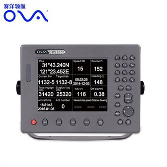
Boat Equipment 15inch GPS Chart Plotter with Class B AIS
MARINE gps marine chart plotter ●Independent research and development of GPS receiver board, positioning accuracy, high stable speed and course ●Support GPS + Beidou Accurate positioning Professional Grade Performance without the High End Price Tag Marine GPS Waterproof Sunlight Viewable OVA gps...
Product Introduction
Creating international brands and enhancing the added value of echo sounder transducer fish finder transducer, boat gps fish finder, boat gps navigation marine are our core competitiveness. Our management philosophy is to keep pace with the times, develop and innovate, realize personal value, and let innovation permeate the whole process of management. In order to build a better brand image, we aim to operate with integrity, innovate continuously, and fully implement high-quality services. We firmly believe that the company will establish a better brand image in domestic and even global enterprises. In order to allow our customers buy comfortably and use them at ease, our production staff have gone through countless experiments and tests to get the final perfect product. Paired with flexible manufacturing systems, we deliver a wide range of the best quality products within a competitive lead time and the most professional services to our customers in an array of applications and industries.
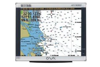
GPS marine chart plotters are widely used for navigation at sea, integrating electronic navigation charts with GPS data.
●Independent research and development of GPS receiver board, positioning accuracy, high stable speed and course
●Support GPS + Beidou Accurate positioning
Professional Grade Performance without the High End Price Tag
Marine GPS Waterproof Sunlight Viewable
Performance Parameter of the Gps Marine Chart Plotter
| |
Model | GBS9000-08 |
Power Supply | DC 24V(11~35V) |
Power Consumption | 15+1W |
Power | High-performance, full isolated PWM control of power supply |
Mount | Bracket Mount or Flush Mount |
Display Size | 8’’ |
Screen Resolution | 800*600px |
Language | Simple Chinese, English, Traditional Chinese |
Navigation Characteristics | |
Data Storage | Waypoints:6000;Marks:5000,Routes:200, 48 waypoints/Route Tracks≤800 (Track Points≤20000) |
Data Display | Suspension Data: Information of ship’s latitude, longitude, fish zone, speed, course; Navigation information of waypoints and routes; Time, date and so on. |
Other Functions | Tide and Compass Pages; AIS Display and Alarm, AIS Message, Vessel Management(if input AIS) |
GPS Characteristics | |
Receive Type | GPS/Glonass/Galileo/Beidou |
Receive Channel | GPS: 1575.42MHz(L1) Beidou: 1561.098MHz(L) |
Aquisition Time | Cold Start: 45s Hot Start: 15s |
Accuracy | GPS:<13m(95%) Beidou: Horizontal 25m(95%) Vertical 30m(95%) |
Interface | |
Input/Output | GPS/Beidou(GGA, GSA, GLL, GSV, RMC, VTG) |
Output | AIS(VDM) |
SD Card | Update software and chart, import and export data |


OVA gps marine chart plotter, Independent research and development of GPS receiver board, positioning accuracy, high stable speed and course.We have a wide range of products to meet your every Marine navigation need.
At the same time, we do the job actively to do research and improvement for Boat Equipment 15inch GPS Chart Plotter with Class B AIS. Our company creates people's power with brand and creates new profit market with brand acceptance. We combine foreign advanced information technology, management methods and enterprise experience with the specific reality of domestic enterprises to provide the most professional product solutions in all aspects.
Hot Tags: gps marine chart plotter, manufacturers, suppliers, wholesale, custom, buy, best, price, on sale, for sale, gps marine navigation, boat gps fish finder, Marine Boat Depth Transducer, 1kw transducer, automatic identification system for ship, BOAT SONAR FISH FINDER
You Might Also Like
-
Yacht Marine GPS AIS Search and Rescue Radar Transponder Sart
-

The Legendary Reputation Lucky 180m Depth Fishing Finder
-

Sincotech Digital GPS Compass Pitch Roll Display Gauge GPS Speed Indicator (DO912)
-

Bometrics Fingerprint Door Access Lock System with Tt Lock APP (UL-650)
-
4MHz Underwater Ultrasonic Transducer for Depth Measurement
-

The Legendary Reputation Lucky GPS Fishing Finder
Send Inquiry