
40kHz Ultrasonic Transducer Depth Measurement for Underwater Communications
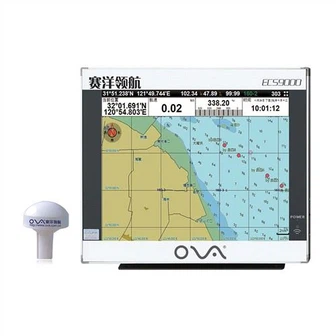
Product Description Marine GPS plotter AIS9000-L190 detailed satellite image maps, electronic chart, AIS target information and AIS group management, strong alarm warning system, can be connected with radar, sonar, compass and other different kinds of sensors for multi-image display. Product...
Product Introduction
We provide fantastic energy in top quality and advancement, merchandising, gross sales and marketing and operation for BOAT SONAR FISH FINDER, 1kw transducer, Marine Transducer 200khz. Our company sticks to the principle of 'high quality, reasonable price and timely delivery'. We always adhere to the new development concept and resolutely implement the new development strategy. All employees of our company uphold the core values of "innovation, integrity, diligence, pragmatism, unity and persistence". We will keep pace with the times, constantly introduce talents, improve the management mechanism, increase R & D efforts, and continue to provide products and perfect services for the majority of users!
High-sensitivity 19-inch color TFT display GPS Chartplotter For Marine
Product Description of the GPS Chartplotter For Marine
Marine GPS plotter AIS9000-L190 detailed satellite image maps, electronic chart, AIS target information and AIS group management, strong alarm warning system, can be connected with radar, sonar, compass and other different kinds of sensors for multi-image display.
Product Specification of the GPS Chartplotter For Marine
•Voltage: DC 24V(11-35V)
•Power Consumption: ≤20W
•Bandwidth: 25KHz
•Frequency:161.975~162.025MHz
•Mount:Bracket Mount or Flush Mount
•Power: High-performance, full isolated, PWM control
•User Data: 50000 waypoints, 200 routes, 10000 waypoints per route. 20000 tracks, 500 tracks per AIS.
•Language:Simple Chinese, Traditional Chinese, English(Can be customized)
•Navigation Data: Bearing, Present Distance, Distance to the Destination, Yaw Distance, Yaw Angle, Navigation Arrow, Sailing Time, ETA(Estimated Time of Arrival), Navigation Distance, Average Speed, Maximum Speed, Target Fishing Zone, etc.
•GPS Performance:Adopting advanced technology of high stable navigational speed and course
•Own Ship Data: Position, speed, course, heading, altitude, present fishing zone, GPS positioning mode
Model | AIS9000-L190 | |
Display Size | 19" | |
Resolution | 1024x768 | |
442mmx362mmx100mm | ||
Display Mode | TFT LCD COLOR Display | |
Operating Mode | Infrared remote control | |
Language | Simple Chinese, English, Traditional Chinese | |
Voltage Range | 11~35V DC | |
Power | High performance, full isolated PWM control of power supply | |
Power Dissipation | ≤30W | |
Safe Distance of Compass | ≥1.5m | |
AIS Function | TX Channel | 1 ch |
RX Channel | 2 ch | |
RF Out Power | 2W | |
Receive Frequency | 156.025~162.025MHz | |
Default Channel | CH2087,CH2088 | |
Bandwidth | 25KHz | |
Modulation Mode | GMSK | |
Receive Sensitivity | Superior to-107dBm | |
TX Channel | 87B/161.975MHz | |
RX Channel | 88B/162.025MHz | |
GPS Receiver | Adopt high speed stable technology | |
GPS positioning accuracy:≤15m, 95% accuracy | ||
Positioning time:cold start 45s, warm start 15s | ||
Navigation Performance | Waypoints:6000 points | |
Marks:5000 points | ||
Route:200 routes,each route contains 48 waypoints | ||
Track:≥200 routes | ||
Include the tide and compass | ||
Intelligent collision avoidance | ||
Interface | 1.GPS output:RS-422, NMEA0183, 4800bps | |
2.AIS input & output:RS-422, NMEA0183, 38400bps | ||
3.Sonar input & output:RS-422, NMEA0183, 115200bps | ||
4.GPS Antenna Interface:BNC base, impedence 50Ω | ||
5.VHF Antenna Interface:UHF base, impedence 50Ω | ||
Environment | Temperature | -15℃~50℃ |
Protection Level | IP44 | |
Standard Annex
| 1. GPS Antenna | |
2. Power Line | ||
3. Safety Fuse, Locking Screws | ||
4. Manual, Certificate, Warranty Card | ||
Packing&Shipping
Delivery Time | 2~5days: DHL,FedEx,UPS,etc. |
Payment Terms | T/T, western union, paypal, alipay, irrevocable LC at sight |
Packaging | gift box + strong protection carton boxes suitable for long term delivery |
Shipping | DHL, UPS, FEDEX, TNT, EMS, by air, by sea, China post, any way you think is suitable |

Company Information
Nantong Saiyang Electronics Co., Ltd. established in 2003, which is specialized in researching and developing, manufacturing and sales of marine radio communication and navigation equipment. Our company is a technology, industry and sales high-tech enterprise. Our main products are Ultrasonic Transducers, Marine Electronic Navigator, Echo Sounder, AIS Navigator, Electronic Chart System(ECS), etc. Our products are widely accepted by our customers because of high technology and good functions.
Our company has a 1500-square-meter marine navigation products production center with preproduction, testing, manufacturing, warehouse as a whole. It is fully equipped and with complete functions for more than 50 million annual production capacity. We have passed China CCS and ISO9000 verification in 2009.
Our company possesses a selling network along the rivers and sea at home and abroad. We have over 100 dealers and annual revenue over 20 million RMB for domestic market. Meanwhile, our communication and navigation equipment have also been exported to over sea market for both wholesalers and end users. At the same time, our company has a production team with exquisite technique to ensure high quality products.
Our Service

Technical Support
Our company has three senior technicians and twelve professionals with high technological level, abundant specialized research practice experience and strong developing abilities. Meanwhile, our company has cooperated with some institutes of higher education and science & technology institutes to ensure the sustaining development of scientific research and development work.

FAQ of GPS Chartplotter For Marine

With the business philosophy of 'advancing with the times, developing with integrity, and serving attentively', we continue to broaden the scope of service, improve service quality, so as to provide our customers with high-quality and low-cost 40kHz Ultrasonic Transducer Depth Measurement for Underwater Communications. Our company has a leading market share and a good reputation that can not be challenged. We are a well deserved industry leader. Looking ahead to the future, with the rapid economic development, we will continue to expand our facilities, technology and product support.
Hot Tags: gps chartplotter for marine, manufacturers, suppliers, wholesale, custom, buy, best, price, on sale, for sale, 0183 transducer, ova marine rubber transducer, chart plotter marine gps navigator, gps boat marine gps ais, ais marine gps chart plotter, in hull depth transducer nmea 0183
You Might Also Like
-

Best Marine GPS Marine AIS & GPS Chart Plotter for Boat
-

Lucky Fish Finder FF718lic-T Cable Transducer Sensor for Shore Fishing
-

50kHz Buy Ultrasonic Distance Transducer for Distance Measurement
-

120V PWM Charge Controller Solar Energy System 3kw off Grid Solar Power System 30A
-
Marine Chart Plotter GPS Navigator for Fishing
-
Fish Finder (FS1001B)
Send Inquiry