
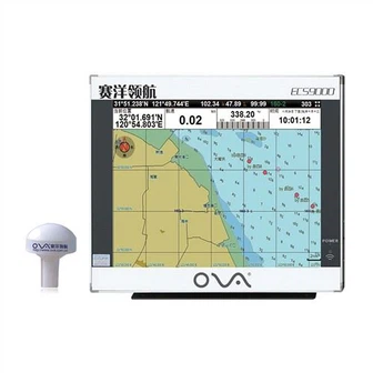
Boat Accessories15 Inch Certification AIS Transponder GPS Chart Plotter for Marine
MARINE gps marine chart plotter ●Independent research and development of GPS receiver board, positioning accuracy, high stable speed and course ●Support GPS + Beidou Accurate positioning Professional Grade Performance without the High End Price Tag Marine GPS Waterproof Sunlight Viewable OVA gps...
Product Introduction
In order to ensure the product quality of the company, our company constantly improves and improves the detection methods, implements scientific quality management and strives to supply customers with high-quality BOAT SONAR FISH FINDER, marine transducers, underwater depth transducer. We sincerely welcome friends from over the world to visit our company and cooperate with us on the basis of long-term and mutual benefits. We have established the concept that 'market changes are the direction of the enterprise, and the needs of users are the goal of the enterprise'. We will serve the needs of users with advanced technology, quality and reputation. We have established and improved a position management system that is compatible with talent capabilities, and strive to form a performance-first talent evaluation system.
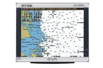
GPS marine chart plotters are widely used for navigation at sea, integrating electronic navigation charts with GPS data.
●Independent research and development of GPS receiver board, positioning accuracy, high stable speed and course
●Support GPS + Beidou Accurate positioning
Professional Grade Performance without the High End Price Tag
Marine GPS Waterproof Sunlight Viewable
Performance Parameter of the Gps Marine Chart Plotter
| |
Model | GBS9000-08 |
Power Supply | DC 24V(11~35V) |
Power Consumption | 15+1W |
Power | High-performance, full isolated PWM control of power supply |
Mount | Bracket Mount or Flush Mount |
Display Size | 8’’ |
Screen Resolution | 800*600px |
Language | Simple Chinese, English, Traditional Chinese |
Navigation Characteristics | |
Data Storage | Waypoints:6000;Marks:5000,Routes:200, 48 waypoints/Route Tracks≤800 (Track Points≤20000) |
Data Display | Suspension Data: Information of ship’s latitude, longitude, fish zone, speed, course; Navigation information of waypoints and routes; Time, date and so on. |
Other Functions | Tide and Compass Pages; AIS Display and Alarm, AIS Message, Vessel Management(if input AIS) |
GPS Characteristics | |
Receive Type | GPS/Glonass/Galileo/Beidou |
Receive Channel | GPS: 1575.42MHz(L1) Beidou: 1561.098MHz(L) |
Aquisition Time | Cold Start: 45s Hot Start: 15s |
Accuracy | GPS:<13m(95%) Beidou: Horizontal 25m(95%) Vertical 30m(95%) |
Interface | |
Input/Output | GPS/Beidou(GGA, GSA, GLL, GSV, RMC, VTG) |
Output | AIS(VDM) |
SD Card | Update software and chart, import and export data |


OVA gps marine chart plotter, Independent research and development of GPS receiver board, positioning accuracy, high stable speed and course.We have a wide range of products to meet your every Marine navigation need.
Our company's production lines are all introduced from abroad to ensure high standard and production quality of the Boat Accessories15 Inch Certification AIS Transponder GPS Chart Plotter for Marine. With the increasingly fierce market competition, the company actively cooperates with relevant suppliers to form strategic partnerships, because more exchanges and cooperation will improve our customer service capabilities and promote the company's healthy development. Fierce market competition requires our company to quickly respond to changes in market demand, and even the ability to guide market demand.
Hot Tags: gps marine chart plotter, manufacturers, suppliers, wholesale, custom, buy, best, price, on sale, for sale, fishfinder chartplotter transducer, echo sounder transducer fish finder transducer, Stainless Steel Transducer, nmea 0183 depth transducer, Gps Marine Chart Plotter, transducers
You Might Also Like
-

a-Td33 1.5kw Rubber Underwater Ultrasonic Transducer for Hondex Fishfinder
-

GPS Marine Yacht Class B AIS Transponder for Ship
-

Boat Compass Marine Electronics Nmea 0183 Satellite Compass for Sale
-
Emergency Position Indicating Radio Beacon
-
150kHz Underwater Ultrasonic Transducer for 200m Depth Measurement
-

8 Inches Marine Fish Finder Ova 801s for Fishing Boat
Send Inquiry