


Boat Car Truck GPS Tracking System 3G GPS Tracker
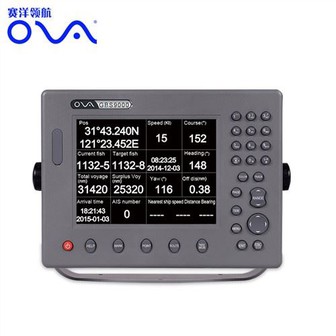
MARINE gps marine chart plotter ●Independent research and development of GPS receiver board, positioning accuracy, high stable speed and course ●Support GPS + Beidou Accurate positioning Professional Grade Performance without the High End Price Tag Marine GPS Waterproof Sunlight Viewable OVA gps...
Product Introduction
Our target should be to consolidate and enhance the top quality and service of current goods, in the meantime frequently create new products to satisfy diverse customers' calls for underwater depth transducer, depth transducer nmea 0183, boat gps fish finder. Our marketing network all over the world constitutes a support system to provide excellent resources for our customers. Selling our products causes no risks and brings high returns to your company instead. Meanwhile, we're building up and consummating triangle market & strategic cooperation in order to achieve a multi-win trade supply chain to expand our market vertically and horizontally for a brighter prospects.
GPS marine chart plotters are widely used for navigation at sea, integrating electronic navigation charts with GPS data.
●Independent research and development of GPS receiver board, positioning accuracy, high stable speed and course
●Support GPS + Beidou Accurate positioning
Professional Grade Performance without the High End Price Tag
Marine GPS Waterproof Sunlight Viewable
Performance Parameter of the Gps Marine Chart Plotter
| |
Model | GBS9000-08 |
Power Supply | DC 24V(11~35V) |
Power Consumption | 15+1W |
Power | High-performance, full isolated PWM control of power supply |
Mount | Bracket Mount or Flush Mount |
Display Size | 8’’ |
Screen Resolution | 800*600px |
Language | Simple Chinese, English, Traditional Chinese |
Navigation Characteristics | |
Data Storage | Waypoints:6000;Marks:5000,Routes:200, 48 waypoints/Route Tracks≤800 (Track Points≤20000) |
Data Display | Suspension Data: Information of ship’s latitude, longitude, fish zone, speed, course; Navigation information of waypoints and routes; Time, date and so on. |
Other Functions | Tide and Compass Pages; AIS Display and Alarm, AIS Message, Vessel Management(if input AIS) |
GPS Characteristics | |
Receive Type | GPS/Glonass/Galileo/Beidou |
Receive Channel | GPS: 1575.42MHz(L1) Beidou: 1561.098MHz(L) |
Aquisition Time | Cold Start: 45s Hot Start: 15s |
Accuracy | GPS:<13m(95%) Beidou: Horizontal 25m(95%) Vertical 30m(95%) |
Interface | |
Input/Output | GPS/Beidou(GGA, GSA, GLL, GSV, RMC, VTG) |
Output | AIS(VDM) |
SD Card | Update software and chart, import and export data |


OVA gps marine chart plotter, Independent research and development of GPS receiver board, positioning accuracy, high stable speed and course.We have a wide range of products to meet your every Marine navigation need.
Extraordinary design and perfect craft creation make our Boat Car Truck GPS Tracking System 3G GPS Tracker always in the leading position. We have a pragmatic leadership, sincere office staff, efficient marketing team. We would like to provide more support for customers.
Hot Tags: gps marine chart plotter, manufacturers, suppliers, wholesale, custom, buy, best, price, on sale, for sale, gps navigation for boat, marine sonar fish finder, Gps Marine Chart Plotter, echo sounder transducer fish finder transducer, marine fishing navigator, marine transducers
You Might Also Like
-

Hot! ! ! 200kHz Marine Fish Finder Transducer for Fishing
-

a-P319n Nnmea 0183 Depth Transducer for Boat Fish Finder
-

Hot Sale AIS9000-L190 Marine GPS AIS Receiver Navigator Chart Plotter
-
Great Will At3 Magnet Wireless GPS GSM Tracker Vehicle Boat Container GPS Tracker
-
Factory Shr IPL Optical System Remove Hair for Salon and Beauty Clinic
-

Rubber Ultrasonic Transducer for Fish Finder or Echo Sounder 50-9b
Send Inquiry