
GPS Marine Boat Electronics Navigator Marine Chart Plotter
MARINE gps marine chart plotter ●Independent research and development of GPS receiver board, positioning accuracy, high stable speed and course ●Support GPS + Beidou Accurate positioning Professional Grade Performance without the High End Price Tag Marine GPS Waterproof Sunlight Viewable OVA gps...
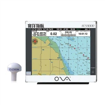
Product Introduction
Our company's production lines are all introduced from abroad to ensure high standard and production quality of the in-hull depth transducer nmea 0183, fishfinder chartplotter transducer, SONAR SENSOR FISH FINDER. Through persistent efforts, we actively expand our business and work hard to achieve our goals. We have done a lot of meticulous work in product technological innovation, production technology, inspection methods and internal management, striving to provide customers with impeccable products.
GPS marine chart plotters are widely used for navigation at sea, integrating electronic navigation charts with GPS data.
●Independent research and development of GPS receiver board, positioning accuracy, high stable speed and course
●Support GPS + Beidou Accurate positioning
Professional Grade Performance without the High End Price Tag
Marine GPS Waterproof Sunlight Viewable
Performance Parameter of the Gps Marine Chart Plotter
| |
Model | GBS9000-08 |
Power Supply | DC 24V(11~35V) |
Power Consumption | 15+1W |
Power | High-performance, full isolated PWM control of power supply |
Mount | Bracket Mount or Flush Mount |
Display Size | 8’’ |
Screen Resolution | 800*600px |
Language | Simple Chinese, English, Traditional Chinese |
Navigation Characteristics | |
Data Storage | Waypoints:6000;Marks:5000,Routes:200, 48 waypoints/Route Tracks≤800 (Track Points≤20000) |
Data Display | Suspension Data: Information of ship’s latitude, longitude, fish zone, speed, course; Navigation information of waypoints and routes; Time, date and so on. |
Other Functions | Tide and Compass Pages; AIS Display and Alarm, AIS Message, Vessel Management(if input AIS) |
GPS Characteristics | |
Receive Type | GPS/Glonass/Galileo/Beidou |
Receive Channel | GPS: 1575.42MHz(L1) Beidou: 1561.098MHz(L) |
Aquisition Time | Cold Start: 45s Hot Start: 15s |
Accuracy | GPS:<13m(95%) Beidou: Horizontal 25m(95%) Vertical 30m(95%) |
Interface | |
Input/Output | GPS/Beidou(GGA, GSA, GLL, GSV, RMC, VTG) |
Output | AIS(VDM) |
SD Card | Update software and chart, import and export data |


OVA gps marine chart plotter, Independent research and development of GPS receiver board, positioning accuracy, high stable speed and course.We have a wide range of products to meet your every Marine navigation need.
Our company has established a people-oriented, leading technology policy and our GPS Marine Boat Electronics Navigator Marine Chart Plotter are developing towards diversification. We implement real-time recycling of leftover materials and defective products, greatly improving economic benefits. Our company actively promotes the upgrading and transformation of industrial structure, enhances our sense of innovation and brand awareness, adjusts our export structure, and strengthens the competitive advantage of our products in the international market.
Hot Tags: gps marine chart plotter, manufacturers, suppliers, wholesale, custom, buy, best, price, on sale, for sale, 0183 transducer, boat depth sounder sensor, ais gps chartplotter, fishfinder chartplotter transducer, boat gps fish finder, Marine Transducer 200khz
You Might Also Like
-

Dual Frequency Sonar WiFi GPS Marine Fishfinder
-

50kHz Boat Underwater Echo Sounder Waterproof Ultrasonic Transducer
-

12 Inch Aluminum China Marine GPS AIS Chart Plotter
-

Zemic Bm6e Load Cell with Capacity 100kg, Stainless Steel Weighing Transducer
-

Ova Marine 15-Inch Deeper Fish Finder GPS Sonar for Fishing
-
Fish Finder (FS1001B)
Send Inquiry