
Marine Navigation Electronics Boat GPS Marine GPS Navigator with Antenna
MARINE gps marine chart plotter ●Independent research and development of GPS receiver board, positioning accuracy, high stable speed and course ●Support GPS + Beidou Accurate positioning Professional Grade Performance without the High End Price Tag Marine GPS Waterproof Sunlight Viewable OVA gps...
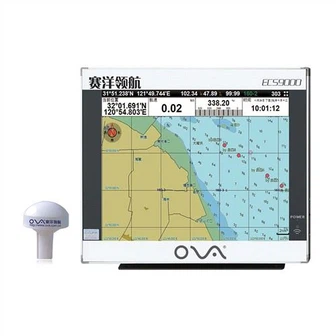
Product Introduction
We love an incredibly fantastic standing amid our consumers for transducer supplier, in-hull depth transducer nmea 0183, ais marine gps chart plotter. Our products have wide interchangeability with similar products in the international arena. The tireless pursuit of high-quality products is our consistent survival rule. We always adhere to customer-centricity and regard good products as our foundation. Please feel free to contact us.
GPS marine chart plotters are widely used for navigation at sea, integrating electronic navigation charts with GPS data.
●Independent research and development of GPS receiver board, positioning accuracy, high stable speed and course
●Support GPS + Beidou Accurate positioning
Professional Grade Performance without the High End Price Tag
Marine GPS Waterproof Sunlight Viewable
Performance Parameter of the Gps Marine Chart Plotter
| |
Model | GBS9000-08 |
Power Supply | DC 24V(11~35V) |
Power Consumption | 15+1W |
Power | High-performance, full isolated PWM control of power supply |
Mount | Bracket Mount or Flush Mount |
Display Size | 8’’ |
Screen Resolution | 800*600px |
Language | Simple Chinese, English, Traditional Chinese |
Navigation Characteristics | |
Data Storage | Waypoints:6000;Marks:5000,Routes:200, 48 waypoints/Route Tracks≤800 (Track Points≤20000) |
Data Display | Suspension Data: Information of ship’s latitude, longitude, fish zone, speed, course; Navigation information of waypoints and routes; Time, date and so on. |
Other Functions | Tide and Compass Pages; AIS Display and Alarm, AIS Message, Vessel Management(if input AIS) |
GPS Characteristics | |
Receive Type | GPS/Glonass/Galileo/Beidou |
Receive Channel | GPS: 1575.42MHz(L1) Beidou: 1561.098MHz(L) |
Aquisition Time | Cold Start: 45s Hot Start: 15s |
Accuracy | GPS:<13m(95%) Beidou: Horizontal 25m(95%) Vertical 30m(95%) |
Interface | |
Input/Output | GPS/Beidou(GGA, GSA, GLL, GSV, RMC, VTG) |
Output | AIS(VDM) |
SD Card | Update software and chart, import and export data |


OVA gps marine chart plotter, Independent research and development of GPS receiver board, positioning accuracy, high stable speed and course.We have a wide range of products to meet your every Marine navigation need.
'Customer initially, High-quality first' in mind, we work closely with our prospects and supply them with efficient and specialist companies for Marine Navigation Electronics Boat GPS Marine GPS Navigator with Antenna. We have helped our customers solve their application problems and have received orders from many important international customers. We have the honor to serve some of the famous companies in the world and we are still keep progressing.
Hot Tags: gps marine chart plotter, manufacturers, suppliers, wholesale, custom, buy, best, price, on sale, for sale, navigator marine electronics, marine gps navigator, boat gps fish finder, boat transducer, transducers, marine gps navigator with chartplotter
You Might Also Like
-

Dual Frequency Sonar WiFi GPS Marine Fishfinder
-

12 Inch Aluminum China Marine GPS AIS Chart Plotter
-
Vra60 Marine Automation Electronics Marine Navigation Communication
-
PWM 24V 30A Solar System Controller Solar Charger Controller
-

Ova Professional Marine Sonar 15 Inch Fish Detector, Fish Finder, Fish Probe
-

Jc Series Ceramic Pressure Sensor / Transducer Custom Manufacturer
Send Inquiry