
Marine Navigation Sonar GPS/ Chart Plotter/ Echo Sounder
MARINE gps marine chart plotter ●Independent research and development of GPS receiver board, positioning accuracy, high stable speed and course ●Support GPS + Beidou Accurate positioning Professional Grade Performance without the High End Price Tag Marine GPS Waterproof Sunlight Viewable OVA gps...
Product Introduction
Our BOAT SONAR FISH FINDER, gps marine navigation, SONAR SENSOR FISH FINDER has reasonable production process, stable product quality, and is suitable for large-scale production. We welcome an prospect to do enterprise along with you and hope to have pleasure in attaching even more aspects of our items. Continuously improving and perfecting quality management, and continuing to provide customers with high-quality products and services are our eternal goals. Our company has a group of management personnel with strategic vision and professional and technical personnel who understand technology and a large number of skilled personnel with rich practical experience, respect for the post and love the industry and superb skills.
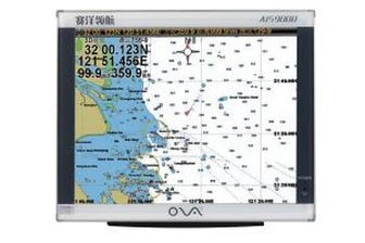
GPS marine chart plotters are widely used for navigation at sea, integrating electronic navigation charts with GPS data.
●Independent research and development of GPS receiver board, positioning accuracy, high stable speed and course
●Support GPS + Beidou Accurate positioning
Professional Grade Performance without the High End Price Tag
Marine GPS Waterproof Sunlight Viewable
Performance Parameter of the Gps Marine Chart Plotter
| |
Model | GBS9000-08 |
Power Supply | DC 24V(11~35V) |
Power Consumption | 15+1W |
Power | High-performance, full isolated PWM control of power supply |
Mount | Bracket Mount or Flush Mount |
Display Size | 8’’ |
Screen Resolution | 800*600px |
Language | Simple Chinese, English, Traditional Chinese |
Navigation Characteristics | |
Data Storage | Waypoints:6000;Marks:5000,Routes:200, 48 waypoints/Route Tracks≤800 (Track Points≤20000) |
Data Display | Suspension Data: Information of ship’s latitude, longitude, fish zone, speed, course; Navigation information of waypoints and routes; Time, date and so on. |
Other Functions | Tide and Compass Pages; AIS Display and Alarm, AIS Message, Vessel Management(if input AIS) |
GPS Characteristics | |
Receive Type | GPS/Glonass/Galileo/Beidou |
Receive Channel | GPS: 1575.42MHz(L1) Beidou: 1561.098MHz(L) |
Aquisition Time | Cold Start: 45s Hot Start: 15s |
Accuracy | GPS:<13m(95%) Beidou: Horizontal 25m(95%) Vertical 30m(95%) |
Interface | |
Input/Output | GPS/Beidou(GGA, GSA, GLL, GSV, RMC, VTG) |
Output | AIS(VDM) |
SD Card | Update software and chart, import and export data |


OVA gps marine chart plotter, Independent research and development of GPS receiver board, positioning accuracy, high stable speed and course.We have a wide range of products to meet your every Marine navigation need.
Since its inception, our company has been committed to providing high quality Marine Navigation Sonar GPS/ Chart Plotter/ Echo Sounder and value-added services to our customers. We are able to provide customers with high quality products and efficient services at all times. We provide our customers with the most stable, reliable and advanced products and solutions, and ensure that each product and each project implementation can maximize the actual effect.
Hot Tags: gps marine chart plotter, manufacturers, suppliers, wholesale, custom, buy, best, price, on sale, for sale, navigator marine electronics, marine transducers, 0183 transducer, marine gps navigator, Gps Marine Chart Plotter, nmea 0183 smart depth transducer for sale
You Might Also Like
-

8 Inches Marine Navigation Build-in Fish Finder GPS Chart Plotter
-

Fish Finder Dual Frequency Ultrasonic Transducer
-

Stainless Steel Monocrystalline Differential Silicon Pressure Sensor/Transmitter/Transducer
-

200kHz Sonar Transducer Ultrasonic Transducer for Koden Echo Sounder
-
Custom Underwater Acoustic Transducer Ultrasonic Depth Transducer
-
40kHz Ultrasonic Transducer Depth Measurement for Underwater Communications
Send Inquiry