
New Marine Heading Navigation Boat Compass GPS Satellite Compass
MARINE gps marine chart plotter ●Independent research and development of GPS receiver board, positioning accuracy, high stable speed and course ●Support GPS + Beidou Accurate positioning Professional Grade Performance without the High End Price Tag Marine GPS Waterproof Sunlight Viewable OVA gps...
Product Introduction
As a professional manufacturer of ova marine rubber transducer, transducers, nmea0183 echo sounder ultrasonic transducer, our company has domestic first-class technical strength, coupled with advanced equipment and strict quality management system, which effectively guarantees product performance and quality. We take the integrated human resource development as a means, based on the domestic, facing the world, and hope to build a talent highland with comprehensive competitiveness. We also continuously innovated and improved our enterprise management system to improve efficiency, providing professional, reliable and high-quality products to serve customers around the world. It is only by reducing product costs through technological innovation that the economic efficiency of the company can be improved and remains invincible in fierce competition. We are aware of the obvious trend of internationalization. In addition to devoting ourselves to research and development and production and actively expanding the market, we are moving forward to the business philosophy of brand marketing and sustainable enterprise.
GPS marine chart plotters are widely used for navigation at sea, integrating electronic navigation charts with GPS data.
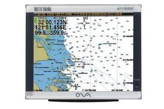
●Independent research and development of GPS receiver board, positioning accuracy, high stable speed and course
●Support GPS + Beidou Accurate positioning
Professional Grade Performance without the High End Price Tag
Marine GPS Waterproof Sunlight Viewable
Performance Parameter of the Gps Marine Chart Plotter
| |
Model | GBS9000-08 |
Power Supply | DC 24V(11~35V) |
Power Consumption | 15+1W |
Power | High-performance, full isolated PWM control of power supply |
Mount | Bracket Mount or Flush Mount |
Display Size | 8’’ |
Screen Resolution | 800*600px |
Language | Simple Chinese, English, Traditional Chinese |
Navigation Characteristics | |
Data Storage | Waypoints:6000;Marks:5000,Routes:200, 48 waypoints/Route Tracks≤800 (Track Points≤20000) |
Data Display | Suspension Data: Information of ship’s latitude, longitude, fish zone, speed, course; Navigation information of waypoints and routes; Time, date and so on. |
Other Functions | Tide and Compass Pages; AIS Display and Alarm, AIS Message, Vessel Management(if input AIS) |
GPS Characteristics | |
Receive Type | GPS/Glonass/Galileo/Beidou |
Receive Channel | GPS: 1575.42MHz(L1) Beidou: 1561.098MHz(L) |
Aquisition Time | Cold Start: 45s Hot Start: 15s |
Accuracy | GPS:<13m(95%) Beidou: Horizontal 25m(95%) Vertical 30m(95%) |
Interface | |
Input/Output | GPS/Beidou(GGA, GSA, GLL, GSV, RMC, VTG) |
Output | AIS(VDM) |
SD Card | Update software and chart, import and export data |


OVA gps marine chart plotter, Independent research and development of GPS receiver board, positioning accuracy, high stable speed and course.We have a wide range of products to meet your every Marine navigation need.
Our advantages are lower prices, dynamic sales team, specialized QC, strong factories, high quality products and services for New Marine Heading Navigation Boat Compass GPS Satellite Compass. We have demonstrated a strong sense of social responsibility by vigorously developing a circular economy. Through our business and social activities, we will do our best to fulfill our responsibilities as a social public entity.
Hot Tags: gps marine chart plotter, manufacturers, suppliers, wholesale, custom, buy, best, price, on sale, for sale, boat depth sounder sensor, gps navigation for boat, SONAR SENSOR FISH FINDER, transducers, marine gps navigator with chartplotter, echo sounder transducer fish finder transducer
You Might Also Like
-

19 Inch Marine AIS System Class B GPS Chartplotter
-

50/200kHz Transducer for Fish Finder Marine Ultrasonic Transducer
-

Pcmpt01 to Pcmpt03 Series Stainless Steel Economical Melt Pressure Transducer
-
Underwater Depth Ultrasonic Sensor High Resolution Ultrasonic Transducer
-
Custom 6kHz Cylindrical Underwater Acoustic Transducer for Depth Measurement
-
10 16 25 bar Low Price 0.5 4.5V 4-20mA Hydraulic Water Pump Pressure Transducer
Send Inquiry