
T100 10" Marine GPS Navigation System GPS Chart Plotter
MARINE gps marine chart plotter ●Independent research and development of GPS receiver board, positioning accuracy, high stable speed and course ●Support GPS + Beidou Accurate positioning Professional Grade Performance without the High End Price Tag Marine GPS Waterproof Sunlight Viewable OVA gps...
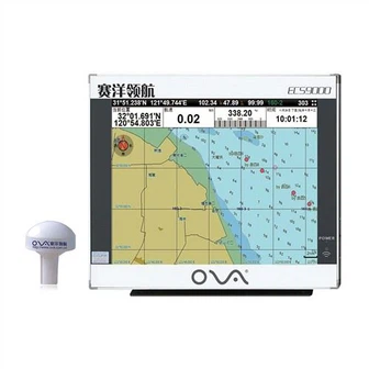
Product Introduction
Our ova marine rubber transducer, chart plotter marine gps navigator, ais marine gps chart plotter is stable, safe and reliable, complete in specifications and diverse in variety. In the future, we will be based on innovative industry value, through a variety of means such as development methods and business model innovation, to achieve the goal of industry value enhancement. Nowadays our merchandise sell all over the domestic and abroad thanks for the regular and new customers support. Relying on convenient transportation and strong regional advantages, our company develops rapidly, and has strong technology development strength and production and processing capacity. In today's market conditions, demand is often changing, thus we need always pay attention to customer needs if we want to long-term development.
GPS marine chart plotters are widely used for navigation at sea, integrating electronic navigation charts with GPS data.
●Independent research and development of GPS receiver board, positioning accuracy, high stable speed and course
●Support GPS + Beidou Accurate positioning
Professional Grade Performance without the High End Price Tag
Marine GPS Waterproof Sunlight Viewable
Performance Parameter of the Gps Marine Chart Plotter
| |
Model | GBS9000-08 |
Power Supply | DC 24V(11~35V) |
Power Consumption | 15+1W |
Power | High-performance, full isolated PWM control of power supply |
Mount | Bracket Mount or Flush Mount |
Display Size | 8’’ |
Screen Resolution | 800*600px |
Language | Simple Chinese, English, Traditional Chinese |
Navigation Characteristics | |
Data Storage | Waypoints:6000;Marks:5000,Routes:200, 48 waypoints/Route Tracks≤800 (Track Points≤20000) |
Data Display | Suspension Data: Information of ship’s latitude, longitude, fish zone, speed, course; Navigation information of waypoints and routes; Time, date and so on. |
Other Functions | Tide and Compass Pages; AIS Display and Alarm, AIS Message, Vessel Management(if input AIS) |
GPS Characteristics | |
Receive Type | GPS/Glonass/Galileo/Beidou |
Receive Channel | GPS: 1575.42MHz(L1) Beidou: 1561.098MHz(L) |
Aquisition Time | Cold Start: 45s Hot Start: 15s |
Accuracy | GPS:<13m(95%) Beidou: Horizontal 25m(95%) Vertical 30m(95%) |
Interface | |
Input/Output | GPS/Beidou(GGA, GSA, GLL, GSV, RMC, VTG) |
Output | AIS(VDM) |
SD Card | Update software and chart, import and export data |


OVA gps marine chart plotter, Independent research and development of GPS receiver board, positioning accuracy, high stable speed and course.We have a wide range of products to meet your every Marine navigation need.
With our loaded practical experience and thoughtful solutions, we now have been identified for T100 10" Marine GPS Navigation System GPS Chart Plotter. No matter under any conditions or in any process, we always maintain the positive attitude of the winners and be brave to pioneer. Our company has always regarded good reputation as the biggest affirmation of our customers. We value credibility and quality, and we will provide you with high quality products and perfect after-sales service as always.
Hot Tags: gps marine chart plotter, manufacturers, suppliers, wholesale, custom, buy, best, price, on sale, for sale, boat gps fish finder, nmea 0183 depth transducer, transducer for fishfinder, automatic identification system for ship, echo sounder transducer, chart plotter marine gps navigator
You Might Also Like
-

CCS Approved Marine Navigational Echo Sounder
-

Professional 12inch High Sensitive Fish Finder
-

Marine GPS Chart Plotter with AIS Transponder and Receiver
-

Great Will At3 Magnet Wireless GPS GSM Tracker Vehicle Boat Container GPS Tracker
-

1200W Stainless Steel Customizable Immersion Ultrasonic Vibration Plate Ultrasonic Transducers
-
Personal Epirb Beacon Hiking Emergency Locator
Send Inquiry