


satellite compass
Product Description GPS COMPASS GNSS-powered high accuracy compass High precision and accurate heading of 0.4° (GC901) Perfect for Radar, ECDIS, AIS, Doppler Sonar and Autopilots Features: GC901 provides a high system accuracy for the heading of the ship, 0.4° Provides highly accurate heading...
Product Introduction
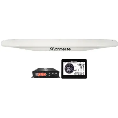
satellite Compass SC90
GNSS-powered high accuracy compass
High precision and accurate heading of 0.4° (SC901)
Perfect for Radar, ECDIS, AIS, Doppler Sonar and Autopilots

- IMO Type-approved as THD, GPS. Complying with the IC, ISO requirements.
- Pre-type carrier phase decoding technology for more precise direction;
- Utilizes GNSS such as Beidou, GPS, GLONASS,and Galileo for high precision attitude;
- Advanced speed and course filtering technology to make the data more stable;
- Built-in gyro compensation system has better heading performance;
- It features fast startup, signal recapture capability, heading updates at up to 50 times per second, and the turning tracking rate up to 90%;
- Multi-channel standard NMEA0183 output, providing high-stability, high-precision ship heading data and positioning data for Radar, ARPA, ECDIS, AIS, Chart Plotter, Autopilot, Sonar and other marine navigation equipment;
- Excellent industrial product design, stylish appearance, easy installation;
- Maintenance free and no recurring cost as there are no mechanical parts;
- This device is not affected by water temperature or salinity; however, in complex sea condi-tions, precautions should be taken against strong winds and heavy rain.
Antenna bracket support selection
We have produced a relatively high-end marine gps satellite compass, why is it high-end?
Data filtering has always been our strong point. GPS speed and heading stability has been around for many years in our company.
In data stabilization, data filtering should be very experienced for us.
The orientation of our GNSS compass is fast, and it is not easy to lose lock in bumps and high-speed corners.
We currently exclusively use pre-carrier phase technology. Only pre-decoding can solve these problems, and the data is more accurate. The data delay is small, the real-time performance is good, and the orientation is fast.
All GPS compasses in the market are processed by the post-CPU algorithm of GPS positioning signals, but our GPS compass is different, and we are the only one that uses pre-signal processing.
What is pre-signal processing?
The filtering algorithm is processed before GPS signal positioning. In this way, the positioning accuracy is very high and more accurate, this is the essential difference.
Built-in gyro compensation system has better performance;
Built-in high-precision inertial navigation module, when the satellite navigation signal is weak or temporarily lost, the heading can keep 3min of compensation output without interruption;
It has the characteristics of fast start, signal recapture, heading update up to 20 times per second, and can operate at a continuous turning rate of up to 90° per second;
The display instrument is light-weight design, partial to installation, and multiple display modes are available; Compared with gyro compass, basically no maintenance;
marine gps satellite compass:Multi-channel standard NMEA0183 output, which can be connected to multiple different navigation systems such as radar and AIS.
Application Guide
Core Applications
Primary heading source for commercial vessels, workboats, yachts, and fishing fleets – replaces magnetic compasses to avoid interference from steel hulls, engines, and electronics.
Autopilot & dynamic positioning – delivers stable heading for precise course control, even in rough seas or tight maneuvering.
Navigation system integration – feeds heading, pitch, roll, and heave data to ECDIS, radar, AIS, GPS plotters, and VDR.
Coastal & offshore navigation – reliable in open ocean, harbors, and near bridges/buildings (with backup mode).
Vessel attitude monitoring – provides real-time pitch/roll for stability and safety in heavy weather.
Best Installation Practices
Mount the antenna unit in an unobstructed location with clear sky view (avoid masts, superstructures, or metal obstructions).
Keep away from high-power equipment, radar, and magnetic sources to preserve signal quality.
Use marine-grade sealant for all deck penetrations to prevent water ingress.
Connect to ship's 24V DC power and NMEA 0183 / NMEA 2000 network for data output.
Perform a quick satellite lock test before permanent mounting.
Standard Parts List (What's Included)
1 Antenna unit SC901
2 Junction Box SC900
3 (optional)Display Unit
4 GNSS compass antenna data cable(20m)
5 2Pin power cable (2m)
6 (optional)6Pin data cable(5m)
7 8Pin data cable(3m)
8 (optional)Mounting bracket
9 Installation manual
10 Other installation accessories
FAQ – Frequently Asked Questions
1. How is Marinelite Satellite Compass different from a magnetic compass?
It uses multi‑constellation GNSS (GPS + BeiDou + GLONASS+GALILEO) for heading, so it's immune to magnetic interference from steel, engines, or electronics – no deviation errors or calibration needed for daily use. It also outputs pitch, roll, and heave data, which magnetic compasses cannot provide.
2. What heading accuracy can I expect?
Heading accuracy: 0.4°RMS
Heading resolution: 0.1°,0.01°0.01° requires contact your dealer)
Pitch/ Roll: 0.3° RMS
3. Does it work when satellite signals are blocked (under bridges, in marinas)?
Yes. Built-in high-precision inertial navigation module. When satellite navigation signals are weak or temporarily lost, it can maintain uninterrupted heading compensation output for 3 to 5 minutes.
4. What data interfaces are supported?
Standard NMEA 0183 (default) and optional NMEA 2000 output. Works with all mainstream marine displays, autopilots, ECDIS, and AIS systems – plug‑and‑play for most vessels.
5. How long does it take to get a satellite fix?
Cold start: ≤32s
Hot start / reacquisition: ≤1s
Heading available within seconds after lock.
6. Is calibration required?
No initial calibration for GNSS heading. Only calibrate the backup magnetometer once if you plan to use it in signal‑dead zones.
7. What power supply does it need?
Standard DC 24V (11–36V range), compatible with all commercial and leisure vessel power systems. Low power draw for long voyages.
8. How robust is the unit for marine use?
Antenna unit are IP56 waterproof, salt‑spray resistant, and built to withstand vibration, shock, and extreme temperatures – designed for continuous offshore operation.
9. Can it be used as the primary heading sensor for autopilot?
Absolutely. It's certified for use as a primary heading source for autopilots, dynamic positioning, and radar overlay – far more stable than magnetic compasses in all conditions.
10. What warranty and support do you offer?
We provide a 1‑year global warranty and lifetime technical support. Our team offers remote installation help, calibration guidance, and troubleshooting via email and video.
11. Do you offer OEM/ODM customization?
Yes. As the original manufacturer, we can customize mounting, output protocols, display interfaces, and branding for fleet orders and special vessel types.
Technical parameters:
1. General
|
1.1 Receiving frequency |
GPS/GALILEO/BEIDOU/GLONASS (optional) |
|
1.2 Heading accuracy |
|
|
SC90 |
0.4°RMS |
|
1.3 Heading resolution |
0.1°,0.01°(0.01° requires contact your dealer) |
|
1.4 Rate of Turn |
90°/s |
|
1.5 Position fixing time |
less than 2min |
|
1.6 Attitude accuracy |
Pitch/Roll: 0.3°RMS |
|
1.7 Power supply |
DC11-32V |
2. Interface
|
2.1 Number of port |
|
|
IEC61162(NMEA0183) |
IEC61162-2: 2 port, IEC61162-1: 2 port |
|
AD-10 |
2 port, for heading output |
|
BAM/INS |
2 port |
|
2.2 Data port/Alert port |
|
|
Input |
ACN, HBT |
|
Output |
ALC, ALF, ARC, HBT, HDT, RMC, ROT, THS, HCR GBS*, GGA*, GLL*, GNS*, GRS*, GSA*, GST*, GSV*, HDG*, VTG*, ZDA*, |
|
2.3 Output proprietary sentences |
SHR* |
Note: output the sentence with * requires contact your dealer.
3.Environmental conditions
|
3.1 Ambient temperature |
|
|
Antenna unit |
-25 ℃ to 70 ℃ |
|
Junction box |
-15 ℃ to +55 ℃ |
|
3.2 Relative humidity |
95% or less at +40 ℃ |
|
3.3 IP protection |
|
|
Antenna unit |
IP56(Exposed) |
|
Junction box |
IP20(Protected) |
|
3.4 Vibration |
IEC 60945 Ed.4 |
Hot Tags: satellite compass, manufacturers, suppliers, wholesale, custom, buy, best, price, on sale, for sale, GNSS COMPASS, Satellite Compass
You Might Also Like


Send Inquiry