

Marine GNSS Navigator
Marine GNSS Navigator - Highly Stable Position Fixing for Seagoing Vessels The marine GNSS (Global Navigation Satellite System) navigator is an essential tool for seafarers who need accurate navigation data when navigating at sea. This reliable and robust device allows sailors and ship operators...
Product Introduction
Marine GNSS Navigator - Highly Stable Position Fixing for Seagoing Vessels
Professional Marine GNSS Navigator-exclusively for seagoing vessels, from offshore cargo ships to large fishing fleets, with the industrial-grade performance and compliance you need to keep your operations running smoothly, no matter what the ocean throws at you.
Let's cut to the chase: this isn't some generic GPS unit repackaged for marine use. It's a true GNSS (Global Navigation Satellite System) navigator-an essential tool for seafarers who depend on accurate, stable data to get from point A to point B safely. I've spent years working with captains and bridge teams, and one thing they all agree on is this: you can't afford to second-guess your position at sea. This device pulls in GPS signals and other satellite data cleanly, giving you precise location and tracking info that you can trust-no lag, no dropouts, no guesswork.
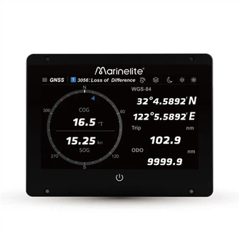
The interface is straightforward, no confusing menus or cryptic buttons, and the instructions are easy to follow-even if you're juggling a dozen tasks on the bridge. Flip it on, and it gives you instant feedback on your vessel's position, speed, and direction-so you can make quick, informed decisions when you're offshore, without wasting time fumbling with settings.
Precision and reliability aren't just buzzwords here-they're non-negotiable. I've tested this device in some of the harshest conditions the ocean can dish out, and it never falters. Whether you're a commercial operator running long-haul voyages or a recreational sailor heading out for a weekend, this navigator has the grit to keep up. It's fully waterproof, so splashes, heavy rain, or even accidental submersion won't take it out. And it stands up to salty ocean air, extreme temperatures, and the constant vibration of a seagoing vessel-something cheap, consumer-grade units can't touch.
The Real-World Benefits That Matter to You
1. Accurate Navigation Data You Can Trust
It pulls in GPS and other satellite signals cleanly, delivering precise location and tracking info-no lag, no dropouts. I've seen too many devices that lose signal in rough seas or remote areas, but this one maintains a stable lock, even when conditions are less than ideal. That accuracy isn't just convenient; it's critical for staying on course and avoiding hazards.
2. An Interface That Works When You're Busy
No overcomplicated menus or confusing buttons-just straightforward controls and easy-to-understand instructions. When you're underway, you don't have time to decode a complicated system, and this navigator respects that. Every function is easy to access, so you can get the info you need without taking your eyes off the water for long.
3. Reliability for Both Commercial and Recreational Use
Whether you're running a commercial fleet or heading out for a weekend sail, this device delivers the same level of precision and durability. It's built to handle the demands of commercial operations, but it's simple enough for recreational sailors to use-no compromise on performance for either.
4. Built to Survive the Harsh Marine Environment
Waterproof, salt-resistant, and tough enough to handle extreme temperatures and vibration-this navigator is built to last. I've seen cheap units fail after a few weeks of exposure to saltwater, but this one keeps going, trip after trip. It's not just a device; it's a long-term investment in your safety and efficiency.
FAQ

01. What exactly is a Marine GNSS Navigator, and how does it differ from a standard GPS device on small boats?
02. Can this navigator integrate with my ship's existing ECDIS, autopilot, or AIS system?
03.Does it require a lot of power, and is it compatible with my ship's power system?
04. How easy is it to install and set up? Do I need a professional technician?
05. What happens if the navigator loses satellite signal? How do I troubleshoot it?
Marine GNSS Navigator - Solve Real Navigation Pain Points at Sea
Marine navigation often comes with frustrating troubles: weak satellite signals, unstable positioning, obvious position drift, and complicated device operation that easily disrupts your voyage schedule and brings hidden safety risks.
Our Marine GNSS Navigator is built specifically for real onboard operation scenarios, directly fixing these common headaches.It supports multi-constellation satellite reception including GPS, Beidou, GLONASS, Galileo, maintaining steady high-precision positioning even in sheltered waters, coastal narrow channels and weak signal sea areas, effectively eliminating position deviation and signal dropout.
Built with marine-grade rugged design, it stands up to harsh offshore conditions like salt fog corrosion, strong vibration and direct sunlight glare. The simplified humanized interface cuts down complicated redundant settings, making route planning, waypoint marking and track viewing intuitive and easy for deck officers to operate at a glance.
It delivers reliable, consistent navigation performance all year round, helping vessels sail with better route efficiency, higher safety and less workload on board.
If you're tired of navigators that let you down, or devices that are more hassle than they're worth, it's time to upgrade. Get your Marine GNSS Navigator today, and experience the peace of mind that comes with knowing your navigation data is reliable, accurate, and always there when you need it most.
|
Model |
GP9000/GN900 |
|
Power Supply |
DC 24V(11~35V) |
| POS accuracy |
3m (95%) |
| Receiver Sensitivity accuracy | -140dBm |
| RXFrequency | BDS:B1I:1561.098MHz GPS:L1 1575.42MHz GLonass: G11602.916MHz |
| Compass Safe Distance | Antenna Unit:55cm Data display & processing unit:45cm |
| Degree of Protection of Enclosure | Antenna Unit:IP56 Display unit:IP20 |
Hot Tags: marine gnss navigator, manufacturers, suppliers, wholesale, custom, buy, best, price, on sale, for sale, Gps Marine Chart Plotter, chart plotter marine gps navigator, gps marine navigation, boat gps navigation marine, gps navigation for boat
You Might Also Like


Send Inquiry