
5.7/8/12 Inches Colorful Display C-Map Card Boat GPS Chart Plotter
MARINE gps marine chart plotter ●Independent research and development of GPS receiver board, positioning accuracy, high stable speed and course ●Support GPS + Beidou Accurate positioning Professional Grade Performance without the High End Price Tag Marine GPS Waterproof Sunlight Viewable OVA gps...
Product Introduction
With the continuous upgrading of the company's research and the expansion of business scope, our company has gradually realized the transformation to a professional marine sonar fish finder, echo sounder transducer fish finder transducer, Satellite Compass supplier. Over the years, through unremitting efforts and exploration, we have become a young, energetic, progressive and positive enterprise. We hope our staff can assiduously study the business knowledge, master the business skills of this position, and constantly improve the business level. We shorten the production cycle, but also improve their own innovation capabilities to adapt to the increasingly fierce global market competition. The stable development of our company benefits from correct development ideas, scientific construction efforts, excellent product quality and continuous improvement of services.
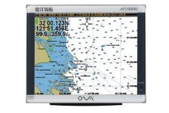
GPS marine chart plotters are widely used for navigation at sea, integrating electronic navigation charts with GPS data.
●Independent research and development of GPS receiver board, positioning accuracy, high stable speed and course
●Support GPS + Beidou Accurate positioning
Professional Grade Performance without the High End Price Tag
Marine GPS Waterproof Sunlight Viewable
Performance Parameter of the Gps Marine Chart Plotter
| |
Model | GBS9000-08 |
Power Supply | DC 24V(11~35V) |
Power Consumption | 15+1W |
Power | High-performance, full isolated PWM control of power supply |
Mount | Bracket Mount or Flush Mount |
Display Size | 8’’ |
Screen Resolution | 800*600px |
Language | Simple Chinese, English, Traditional Chinese |
Navigation Characteristics | |
Data Storage | Waypoints:6000;Marks:5000,Routes:200, 48 waypoints/Route Tracks≤800 (Track Points≤20000) |
Data Display | Suspension Data: Information of ship’s latitude, longitude, fish zone, speed, course; Navigation information of waypoints and routes; Time, date and so on. |
Other Functions | Tide and Compass Pages; AIS Display and Alarm, AIS Message, Vessel Management(if input AIS) |
GPS Characteristics | |
Receive Type | GPS/Glonass/Galileo/Beidou |
Receive Channel | GPS: 1575.42MHz(L1) Beidou: 1561.098MHz(L) |
Aquisition Time | Cold Start: 45s Hot Start: 15s |
Accuracy | GPS:<13m(95%) Beidou: Horizontal 25m(95%) Vertical 30m(95%) |
Interface | |
Input/Output | GPS/Beidou(GGA, GSA, GLL, GSV, RMC, VTG) |
Output | AIS(VDM) |
SD Card | Update software and chart, import and export data |


OVA gps marine chart plotter, Independent research and development of GPS receiver board, positioning accuracy, high stable speed and course.We have a wide range of products to meet your every Marine navigation need.
Our items are exported around the world, enjoying a great popularity among the customers for 5.7/8/12 Inches Colorful Display C-Map Card Boat GPS Chart Plotter. We are committed to providing our customers with one-stop service, keeping every promise to our customers and continuously meeting their requirements. Our brand positioning is to be a strong and famous brand and make our products famous in the market.
Hot Tags: gps marine chart plotter, manufacturers, suppliers, wholesale, custom, buy, best, price, on sale, for sale, nmea 0183 depth transducer for sale, boat gps navigation marine, boat transducer, marine gps navigator with chartplotter, ais marine gps chart plotter, depth sounder transducer
You Might Also Like
-

FF-1108-1cw Lucky Wireless Fish Finder 2~147FT Colored LCD Fishfinder Sensor Sonar Detector Fishing
-

North Navigation Survival Compass Mini Precise Compass Practical Guider for Camping Hiking
-

10 Inch Chart Plotter with Automatic Identification System AIS 9000-10
-
17 Inches LCD Ship AIS Chart Plotter for Boat
-

200kHz Underwater Ultrasonic Transducer for Ultrasonic Flowmeter
-
105kHz Underwater Ultrasonic Depth Transducer for Ultrasonic Flowmeter
Send Inquiry